2010
Press Reviews of TrailRunner and RaceBunny
03.12.10 09:37 Filed in: Gossip

November 30, 2010; review of TrailRunner and RaceBunny at WarriorWomen.co.uk: I think I’ve arrived late to the party but I’ve just stumbled upon a brilliant piece of software that can actually give Sporttracks a run for it’s money. Article Link
TrailRunner and Nike+ GPS app for iPhone
02.11.10 19:46 Filed in: Features
The Nike+GPS importer has the following features:
- Import all your stored workout sessions from your nikeplus.com account into your TrailRunner diary
- Import the recorded GPS track
- Import additional notes taken in the "How was your run" section of the app.
- Compare your sessions using the advanced tools in TrailRunner.
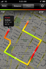
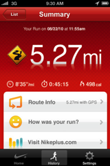
> Read more about how to use The Nike+GPS app with TrailRunner
Use TrailRunner with Suunto Devices
14.10.10 19:14 Filed in: Features
I added an importer for Suunto devices that works with the Suunto Movescount online service and the Suunto Moveslink interface. 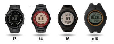
Moveslink is an application that connects your Suunto device to Movescount. Moveslink is always running when you start your computer so you can plug in your device any time.
Set TrailRunner > Preferences > Synchronize > Helper Application to Suunto Moveslink.
In TrailRunner click on the import from device button in the main application toolbar.
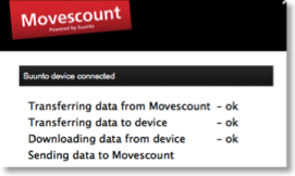
The Suunto MovesLink application will start, automatically downloading your fitness data from your device and uploading the data to Movescount.
Quit the MovesLink application and follow the screen instructions in TrailRunner.
Please note that with all other device data, TrailRunner can only display fitness data that also contains distance information. In this case you should always wear a foot-pod.
> About Suunto Movescount
> About Suunto Moveslink
> Download Suunto Moveslink for Mac OS X
Moveslink is an application that connects your Suunto device to Movescount. Moveslink is always running when you start your computer so you can plug in your device any time.
Set TrailRunner > Preferences > Synchronize > Helper Application to Suunto Moveslink.
In TrailRunner click on the import from device button in the main application toolbar.
The Suunto MovesLink application will start, automatically downloading your fitness data from your device and uploading the data to Movescount.
Quit the MovesLink application and follow the screen instructions in TrailRunner.
Please note that with all other device data, TrailRunner can only display fitness data that also contains distance information. In this case you should always wear a foot-pod.
> About Suunto Movescount
> About Suunto Moveslink
> Download Suunto Moveslink for Mac OS X
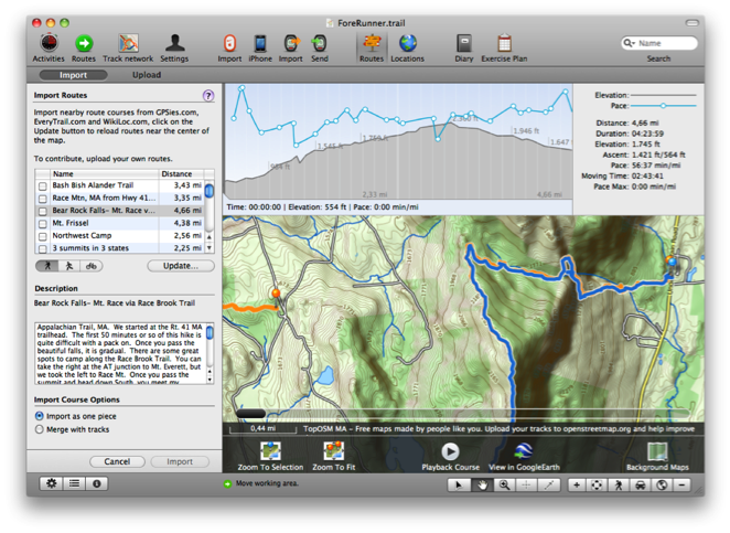
Follow your routes
12.10.10 15:54 Filed in: Features
TrailRunner is the perfect tool to create new routes. Now how could you take these with you?
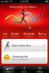
iPhone with Nike+GPS
 [Update] Nike+GPS is available in the app store.
Download and install Nike+GPS app from the AppStore.
Register a nikeplus.com account at nikeplus.com
Make a new recoding with the Nike+GPS app and synchronize your data with nikeplus.com
Set TrailRunner > Preferences > Synchronize > Apple + Nike to nikeplus.com
In the TrailRunner toolbar of the main application window, click on the Nike+Apple Icon.
In TrailRunner, login with your nikeplus.com account data.
TrailRunner will read your workout sessions from your nikeplus.com account
Import selected workouts.
TrailRunner will also import any additional notes taken within the iPhone app.
iPhone with Trails 4
 Trails 4.0 is available in the app store.
Download and install Trails from the AppStore.
Set Trails as your helper application in TrailRunner > Preferences > Synchronize > iPhone.
Trails can send routes to TrailRunner, and Trails can receive routes from TrailRunner
To send routes to Trails:
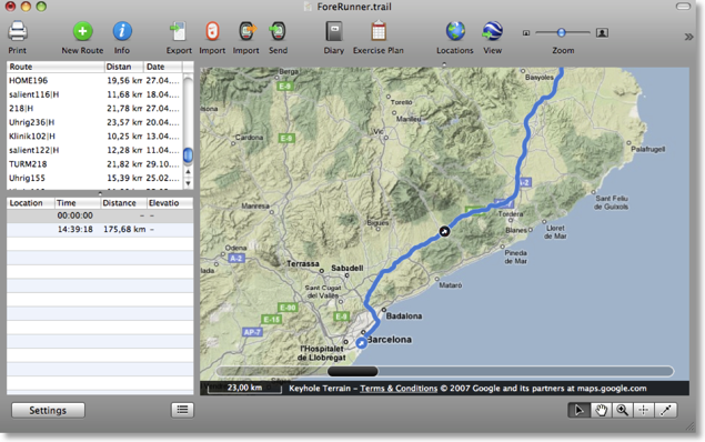
ForeRunner
 To send a route to your ForeRunner you first need to download the Helper Application LoadMyTracks.
Then select a route in TrailRunner and click the Send toolbar button in the main document toolbar.
Click the Export route button and LoadMyTracks will launch and transfer the course to your GPS device.
iPhone with RaceBunny
 Download and install RaceBunny from the AppStore.
Set RaceBunny as your helper application in TrailRunner > Preferences > Synchronize > iPhone.
Follow the instructions as described here: Using RaceBunny with TrailRunner
iPhone with 321run
 321Run is an iPhone coach for running that can send recorded track to TrailRunner.
Download and install 321run from the AppStore.
Set 321run as your helper application in TrailRunner > Preferences > Synchronize > iPhone.
Read more here: Using 321run with TrailRunner.
iPhone with Motion-X GPS
 Download and install MotionX-GPS from the AppStore.
Create a Route in TrailRunner and export the Route as a GPX-track.
Send the GPX file via Mail.app to gpsimport@motionx.com
A Mail message will be returned to you. Open this Mail Message on your iPhone and import the track into Motion-X.
Are you an iPhone App developer interested in the TrailRunner Wifi API?
iPhone with Nike+GPS
Download and install Nike+GPS app from the AppStore.
Register a nikeplus.com account at nikeplus.com
Make a new recoding with the Nike+GPS app and synchronize your data with nikeplus.com
Set TrailRunner > Preferences > Synchronize > Apple + Nike to nikeplus.com
In the TrailRunner toolbar of the main application window, click on the Nike+Apple Icon.
In TrailRunner, login with your nikeplus.com account data.
TrailRunner will read your workout sessions from your nikeplus.com account
Import selected workouts.
TrailRunner will also import any additional notes taken within the iPhone app.
iPhone with Trails 4
Download and install Trails from the AppStore.
Set Trails as your helper application in TrailRunner > Preferences > Synchronize > iPhone.
Trails can send routes to TrailRunner, and Trails can receive routes from TrailRunner
To send routes to Trails:
- In the main document window, click the iPhone icon and in the left pane select the send-tab.
- Start Trails on the iPhone.
- Select a route in TrailRunner and click the send button.
- The selected route is being transferred to Trails and is added to the list of imported tracks.
ForeRunner
Then select a route in TrailRunner and click the Send toolbar button in the main document toolbar.
Click the Export route button and LoadMyTracks will launch and transfer the course to your GPS device.
iPhone with RaceBunny
Set RaceBunny as your helper application in TrailRunner > Preferences > Synchronize > iPhone.
Follow the instructions as described here: Using RaceBunny with TrailRunner
iPhone with 321run
Download and install 321run from the AppStore.
Set 321run as your helper application in TrailRunner > Preferences > Synchronize > iPhone.
Read more here: Using 321run with TrailRunner.
iPhone with Motion-X GPS
Create a Route in TrailRunner and export the Route as a GPX-track.
Send the GPX file via Mail.app to gpsimport@motionx.com
A Mail message will be returned to you. Open this Mail Message on your iPhone and import the track into Motion-X.
Are you an iPhone App developer interested in the TrailRunner Wifi API?
Import FIT files from Garmin Edge 500
17.09.10 18:19 Filed in: Features
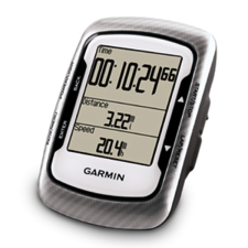
Added Support for the Garmin FIT file format. This is the new data storage format for the Garmin Edge 500 and newer devices.
To synchronize your Edge data with TrailRunner follow these steps:
- Set TrailRunner > Preferences > Synchronize > Helper Application to Garmin USB Mass Storage
- In the Main document toolbar, click on the Import from device icon.
- An import pane should now open on the left, decoding and displaying your stored activities.
Synchronizing your diary
13.09.10 17:12 Filed in: Features

The reason I write this blog entry is that many user request a possibility to sync the diary between two computers.
As you might already know, TrailRunner stores all vital information within your home directories Application Support folder
To do so, follow these steps:
- Download and install Dropbox.
- By default, the Dropbox application creates a new folder in your home directory called Dropbox.
- Open this folder and make sure that a folder named Documents exists within. If not, create it with the exact spelling.
- Now go to: [yourhome]/Library/Application Support/
- Within, find the folder named TrailRunner and move this into the aforementioned Documents folder.
Next time you start up TrailRunner, the application will check on if your home directory contains the following folder:
[yourhome]/Dropbox/Documents/TrailRunner/
If that's the case, TrailRunner will access this location instead of the default Library/Application Support location
Sidenote: To make this practical, TrailRunner will move your local cached map tiles out of the Library/Application Support folder into the Library/Caches folder. This heavily reduces the load on your 2GB free storage at dropbox.com
> www.dropbox.com
Import directions from maps.google
14.08.10 20:06 Filed in: Technology
If you want to import a route planned with maps.google.com into TrailRunner, follow these steps:
Goto maps.google.com and use the Get Directions tab to plan your course.
Click the Link to this page link.
In the Paste link in email or IM edit field, append &output=kml to the end of the url (with no blank inbetween)
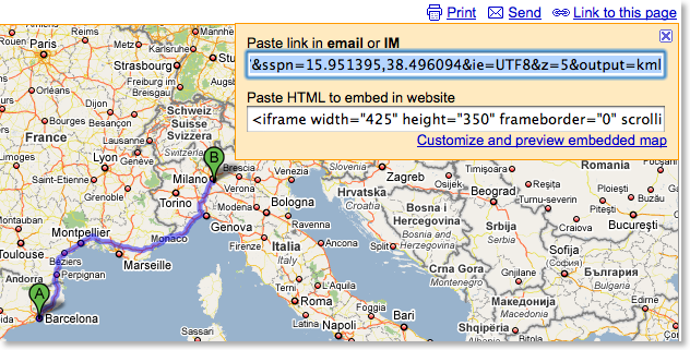
Copy the whole URL and paste it into the address bar. Press the return key.
A kml file will now download. Drag the maps.kml file onto TrailRunner or the main window. The course importer will open.
More convenient alternatives:
Convert Google Maps Data to GPX
> GMapToGPX
> GMapToGPX (German)
Goto maps.google.com and use the Get Directions tab to plan your course.
Click the Link to this page link.
In the Paste link in email or IM edit field, append &output=kml to the end of the url (with no blank inbetween)
Copy the whole URL and paste it into the address bar. Press the return key.
A kml file will now download. Drag the maps.kml file onto TrailRunner or the main window. The course importer will open.
More convenient alternatives:
Convert Google Maps Data to GPX
> GMapToGPX
> GMapToGPX (German)
Sharing GPS Trails
13.05.10 08:29 Filed in: Routes
The internet and the community behind are a great resource. You already know that. The following community sites are a selection where you can upload share and download running, hiking or biking courses:

With GPSies you can view and download tracks which have been recorded by a GPS device. Whether you are searching for running courses or Mountain Bike Tracks, with GPSies you can see what Tracks others have recorded. And you can download all the Tracks and put them onto your GPS device so you won`t lose your way.
http://www.gpsies.com

EveryTrail is a mobile travel companion that enables travelers to Track, Share and Search Trips. EveryTrail also offers apps for iPhone, Android and other mobile platforms.
www.everytrail.com

[Update] Route sharing website based and focusing on the UK.
www.anyonefor.com

Bikely helps cyclists share knowledge of good bicycle routes.
http://www.bikely.com

WikiLoc is a free web app that lets you share GPS tracklogs and waypoints on the web in an easy way
http://www.wikiloc.com

German: Hier findest du kostenlose Touren mit GPS Tracks zu Outdoor Aktivitäten in beliebten Kategorien wie Mountainbiken, Wandern, Reiten, Ski etc.
http://www.gps-tour.info
With GPSies you can view and download tracks which have been recorded by a GPS device. Whether you are searching for running courses or Mountain Bike Tracks, with GPSies you can see what Tracks others have recorded. And you can download all the Tracks and put them onto your GPS device so you won`t lose your way.
http://www.gpsies.com
EveryTrail is a mobile travel companion that enables travelers to Track, Share and Search Trips. EveryTrail also offers apps for iPhone, Android and other mobile platforms.
www.everytrail.com
[Update] Route sharing website based and focusing on the UK.
www.anyonefor.com
Bikely helps cyclists share knowledge of good bicycle routes.
http://www.bikely.com
WikiLoc is a free web app that lets you share GPS tracklogs and waypoints on the web in an easy way
http://www.wikiloc.com
German: Hier findest du kostenlose Touren mit GPS Tracks zu Outdoor Aktivitäten in beliebten Kategorien wie Mountainbiken, Wandern, Reiten, Ski etc.
http://www.gps-tour.info
Screencast for TrailRunner (spanish)
07.05.10 14:56 Filed in: Features
The guys over at slooping.net did a great review of TrailRunner including a 21 minute screencast explaining almost every feature of TrailRunner.
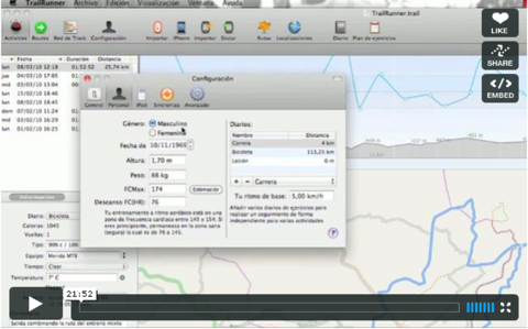
Si usted puede entender español, echa un vistazo:
> TrailRunner: Gestión de tracks y entrenos (incluye screencast detallado)
Si usted puede entender español, echa un vistazo:
> TrailRunner: Gestión de tracks y entrenos (incluye screencast detallado)
Special mentions in media
06.05.10 22:34 Filed in: Gossip
TrailRunner 3.1 has been picked as the editor’s choice on Softonic.

TrailRunner has been granted the "Excellent" certificate at FindMySoft.com

 I am not sure what it's worth, but mac.softpedia.com found TrailRunner to be free of any malicious code like spyware, viruses, trojans and backdoors.
What's more interesting is the fact that softpedia published some screenshots of TrailRunner depicting a map snapshot of a region in Romania near the river Prut. Looks like globalization also caught the software review industry…
> mac.softpedia.com
> Softpedia Screenshot
> Wikipedia Prut
TrailRunner has been granted the "Excellent" certificate at FindMySoft.com
What's more interesting is the fact that softpedia published some screenshots of TrailRunner depicting a map snapshot of a region in Romania near the river Prut. Looks like globalization also caught the software review industry…
> mac.softpedia.com
> Softpedia Screenshot
> Wikipedia Prut
TrailRunner -- Live Performance
14.03.10 22:05 Filed in: Gossip

My first competition this year will be Sunday, March 21st for "Auf die Platte-fertig-los", Wiesbaden, Germany.
As every year this is the first of a series of up-hill races I do. Roughly 8 km with 450 m of ascent.
I wish all of you a successful season!
Take care,
- berbie.
> Get your own…
TrailRunner 3.0 -- Improvements on the way
12.03.10 17:03 Filed in: Features
A quick overview on that has changed in TrailRunner 3.0:
Reworked UI and wording
To better meet the vocabulary being used in other applications, TrailRunner will no longer speak about workouts but activities.
Also activities, routes and your network of tracks are displayed in a better UI.
All application modes now come with their own dedicated toolbar at the bottom end of the window making the UI much more clearer.
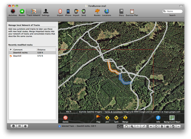
New Network of tracks editor
The new editor makes managing your network of tracks much easier. Drag selection and shift click extent selection lets you select more than one element
Operations on the action toolbar give you the toolset to effectively remove duplicate tracks and waypoints.
A list of modified tracks on the left helps you in finding out what was newly added to your network and may contain duplications to be merged into your network of tracks.
WayPoint Perimeters
 As you know, tracks can be spitted by a waypoint nearby. In previous versions of TrailRunner the maximum distance from a way-point to track to make this happen was a fixed value of 10 meters.
In the new network of tracks editor, you now see this perimeter range around selected waypoints and you can drag the border to extend the range.
This is especially useful when you have locations where great chaos lies within because many routes start and end somewhere around this spot. Now you can just increase the perimeter of one representative for this location and TrailRunner will then be able to better consolidate new elements within this area.
Better OpenStreetMap Source
Changed the Background Map to CloudMade openStreetMap Fine Line with a contour overlay.
To effectively reload all map tiles, remove the
Improved Integration with EveryTrail
 The community routes browser and importer now supports an improved API version for finding routes nearby on everytrail.com. Additionally TrailRunner hilights not only the location of routes nearby but also displays the tracks. So you now easily can view what courses the routes have.
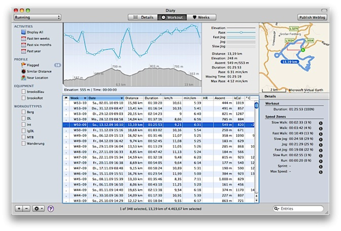
Improved Diary
The diary window now displays a map and more statistical information on the selected activity.
Simplified process of localization
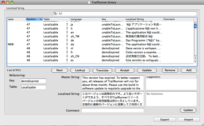
Over the years, the number of strings requiring localization grew to a huge number. A new database based application now helps localizers manage and update the localizations with a very easy interface that also contains a ToDo list and automatic pre-translation provided by translate.google.com
If you would like to help out with an updated or even new localization, please contact me.
QuickGuide for TrailRunner 3.0
The QuickGuide shows you all main features of the application. Great for testing everything out:
> QuickGuide
Reworked UI and wording
To better meet the vocabulary being used in other applications, TrailRunner will no longer speak about workouts but activities.
Also activities, routes and your network of tracks are displayed in a better UI.
All application modes now come with their own dedicated toolbar at the bottom end of the window making the UI much more clearer.
New Network of tracks editor
The new editor makes managing your network of tracks much easier. Drag selection and shift click extent selection lets you select more than one element
Operations on the action toolbar give you the toolset to effectively remove duplicate tracks and waypoints.
A list of modified tracks on the left helps you in finding out what was newly added to your network and may contain duplications to be merged into your network of tracks.
WayPoint Perimeters
In the new network of tracks editor, you now see this perimeter range around selected waypoints and you can drag the border to extend the range.
This is especially useful when you have locations where great chaos lies within because many routes start and end somewhere around this spot. Now you can just increase the perimeter of one representative for this location and TrailRunner will then be able to better consolidate new elements within this area.
Better OpenStreetMap Source
Changed the Background Map to CloudMade openStreetMap Fine Line with a contour overlay.
To effectively reload all map tiles, remove the
Improved Integration with EveryTrail
Improved Diary
The diary window now displays a map and more statistical information on the selected activity.
Simplified process of localization
Over the years, the number of strings requiring localization grew to a huge number. A new database based application now helps localizers manage and update the localizations with a very easy interface that also contains a ToDo list and automatic pre-translation provided by translate.google.com
If you would like to help out with an updated or even new localization, please contact me.
QuickGuide for TrailRunner 3.0
The QuickGuide shows you all main features of the application. Great for testing everything out:
> QuickGuide
Supported Fitness Devices
18.02.10 09:57 Filed in: Technology
TrailRunner directly and indirectly supports several workout recording devices. As it’s very time consuming to directly support fitness devices, I decided to interface with dedicated helper applications that do a much better job than I could do on my own. Go to the TrailRunner application preferences to set the synchonisation for your supported fitness device.
> FAQ Entry on supported fitness devices, GPS receivers and file formats.
> FAQ Entry on supported fitness devices, GPS receivers and file formats.
Testbericht auf Frosthelm.de [de]
25.01.10 15:38 Filed in: Gossip
Die Trails werden mit Action-Videos, Anfahrtsbeschreibung und GPS Daten vorgestellt. Gerade wegen der GPS Daten ist Frosthelm eine guter Fundus für TrailRunner aus dem MTB Bereich.
> Testbericht
> frosthelm.de
Weitere Testberichte
TrailRunner macht Bock aufs Laufen: MACazin.de, 1.1.2008
iTrail und Trailrunner im Test: getfitter.de, 26.01.2009
Dueling Y-Axes
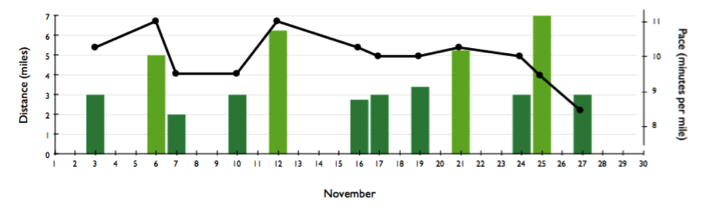
25.01.10 14:49 Filed in: Conceptual
An interesting reading about fanciness and pointlessness of displaying data.
The team at OmniGraphSketcher wrote about the display of multiple y-scales overlaid on the same graph, to make it possible to plot several different types of related data on the same chart. I do this too in TrailRunner but my solution targets the middle of what they call a bad idea and what they suggest as a realistic solution.
The main conclusion of the OmniGraphSketcher team is that overlaying data with disparate scales saves space, but it makes the data significantly harder to interpret. The dual axes “duel” for your attention. So instead of overlaying scales, [they] recommend using a set of multiple graphs, aligned along their common axis.
> Omnimouth blogpost
> Read their Article