29.12.06 18:22 Filed in:
MapsMapDiscovery gets into shape. I am working on it as an easy way to locate yourself on this planet, and to set a starting point in TrailRunner. Instead of the all so popular GoogleEarth digital orthophoto (DOQ) MapDiscovery is specialized on finding topographic maps available from open WMS Servers. Especially the USGS Topo Maps and the Maps from Catalonia and Germany are such great sources with a detail, most can not imagine if haven't seen yet. So for this and other reasons this small application lets you browse around the globe and inspect the best known map sources I know of. >
Download MapDiscovery17.12.06 12:24 Filed in:
Maps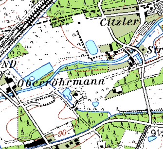
I am happy to announce that I finally got the GeoServer of Nordrhein-Westfalen integrated as a download source. This will open up a very detailed map coverage for the state in Germany with the highest population. To achieve this, I integrated a great package named proj.4 which is simply a framework to transform coordinate systems from one to another. In this case TrailRunner requires the WGS84 Spatial Reference System EPSG:4326 but the WMS Server of NRW only understands the Gauß-Krüger Reference System EPSG:31466, which is very common in Europe. But even though I can transform points from one coordinate system to another, I still have to rotate each map tile I get back from the server. Mostly by 1.06 degrees. And additionally I have to stretch and bulge the tiles horizontally and vertically to get a perfect overlay with the tiles in the neighborhood. Somehow I have the impression that the WMS server does something weird internally and this is the reason why they are unable to provide the EPSG:4326 projection by default. If someone of my honored readers has any deeper knowledge about what could be going on here, please drop me a line. I would be very thankful to discuss this topic and to find an appropriate solution. The quality, the server can deliver, is really worth the effort.
>
PROJ.4 - Cartographic Projections Library15.11.06 20:25 Filed in:
Maps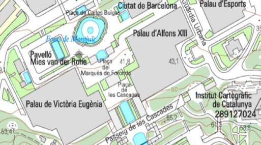
One recent WMS discovery will extend the TrailRunner maps download by maps from Catalunya (Spain). The Institut Cartografic de Catalunya (ICC) provides maps in various resolutions, down to 1:5000. This is by far (yet) the best map source I know of.
If you know other open WMS Servers with good material, please drop me a line.
18.09.06 18:04 Filed in:
GossipTrailRunner today got a special mention as "meilleure utilisation des technologies Apple" (Best usage of Apple technologies) in the MacGeneration Award 2006.
Read about the winners and the mention:
Français OriginalMacNews GermanThis also is a big thank you to all contributors of feedback and new ideas. Even if we hardly speak the same languages.
Tags: press, Awards