2008
TrailRunner 1.9 - Work in Progress
23.12.08 22:13 Filed in: Features
I got a bit quiet on the support front because I am very busy with TrailRunner 1.9
Within this release I am re-factoring a lot of very old code to have a better migration path to 2.0 and later releases. Currently in the works:
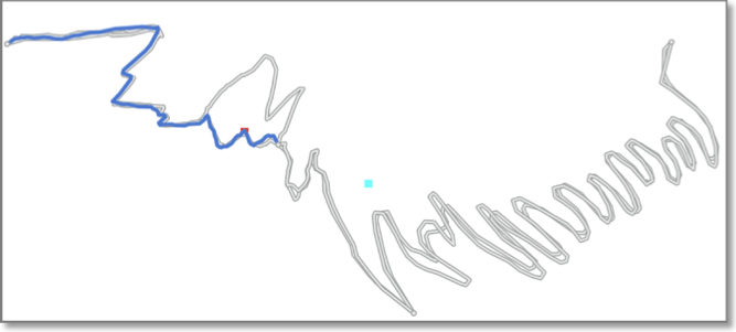
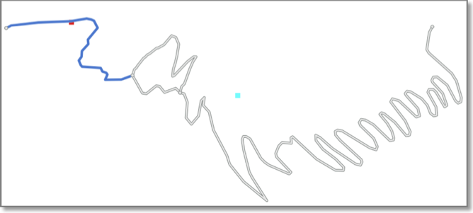
Route and Network Merge -- This now really works. The most complex part of TrailRunner is now much faster and supports full undo for all operations.
Intermediate Tracks -- Already introduced in 1.8 the algorithm is now capable to merge tracks and calculate an intermediate path. This is being done weighted meaning the more often you run a track course and intermediate-merge the recordings, the more accurate the elevation profile will get over time.
Other parts I am working on are still hidden or unused so nothing to talk about at the moment.
In case you would like to become a beta tester, please subscribe to MacDeveloper.net (see post below) I’ll post a first release soon.
Happy Christmas and enjoy the holidays.
- berbie.
Within this release I am re-factoring a lot of very old code to have a better migration path to 2.0 and later releases. Currently in the works:
Route and Network Merge -- This now really works. The most complex part of TrailRunner is now much faster and supports full undo for all operations.
Intermediate Tracks -- Already introduced in 1.8 the algorithm is now capable to merge tracks and calculate an intermediate path. This is being done weighted meaning the more often you run a track course and intermediate-merge the recordings, the more accurate the elevation profile will get over time.
Other parts I am working on are still hidden or unused so nothing to talk about at the moment.
In case you would like to become a beta tester, please subscribe to MacDeveloper.net (see post below) I’ll post a first release soon.
Happy Christmas and enjoy the holidays.
- berbie.
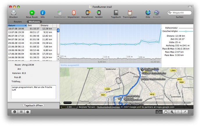
Heartrate zones
23.12.08 22:03 Filed in: Features
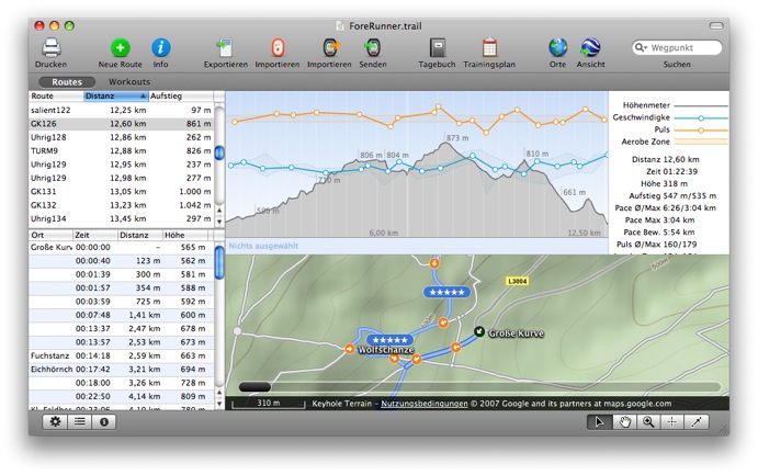
Due to another bugfix I was working on the workout graph and so added heart-rate zones
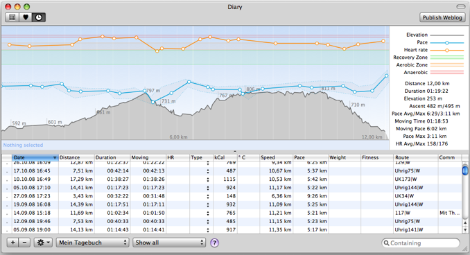
It might get rather philosophical on what heart rate ranges the different zones are defined. I decided on the following:
In green the Energy Efficient or Recovery Zone, up to 60% of you maximum heart-rate to develop a basic endurance and aerobic capacity.
In orange the Aerobic Zone, 60% up to 75% of your maximum heart-rate. Will develop your cardiovascular system.
In red the Anaerobic Zone, 85% up to 90% of your maximum heart-rate. Training in this zone will develop your lactic acid system.
MacDeveloper - Filing TrailRunner Bugs And Feature Requests
05.12.08 23:49 Filed in: Features
TrailRunner is now part of the MacDeveloper Testing Network.
“MacDeveloper helps companies and individual software developers alike improve the quality of their products by providing a platform to have their applications properly tested from a well informed, and energetic Beta Pool. It’s an opt-in service for testers who love what the Mac community offers and genuinely want to test.”
Because MacDeveloper uses a clean and structured interface to sort, comment and file bugs and feature requests I would suggest that everyone wanting to become a beta tester for TrailRunner subscribes to the Testing Network.
But — as always — you can still contact me directly if you have any questions or general feedback. MacDeveloper is just another good way to communicate with me.
Enjoy the holidays…
> MacDeveloper
Slam it! - an iPhone game
26.11.08 09:22 Filed in: Gossip
The other days I was sitting together with some friends and thought about a fun iPhone app. Well, as one thing came to another we decided use the accelerometer in the iPhone and iPod touch to detect if someone has slammed on the table and to point out who’s going to pay the next round.
And here’s the outcome, a 0,79 Euro App in the AppStore:
 “Slam it!” is a fun way to draw sticks, have a shoot-out, find a random winner. Having a kids’ birthday and want to find a team captain? Need to determine who’s paying the next round? Who will be the designated driver? Which poor soul in your shared flat will do the dishes? Don’t just agree on it or, god forbid, command it – no, slam it!
Put your iPhone or iPod touch on a table or desk. Gather the participants around your precious and have them select a playing field by placing a finger on the screen. (Explain to them this is the only circumstance under which you’ll let their greedy paws touch it!) Once everyone lifts their finger, the spinner will start.
Now here’s the twist: While the spinner will eventually decelerate and randomly point out a winner (or loser!) you can influence fate by slamming on the table. When you do so, the spin-down will start and select the loser not so randomly...
“Slam it!” can be played in two game modes (Protect Yourself and Last Player Wins) and comes with three themes to choose from.
Have fun!
> Website
> AppStore
And here’s the outcome, a 0,79 Euro App in the AppStore:
Put your iPhone or iPod touch on a table or desk. Gather the participants around your precious and have them select a playing field by placing a finger on the screen. (Explain to them this is the only circumstance under which you’ll let their greedy paws touch it!) Once everyone lifts their finger, the spinner will start.
Now here’s the twist: While the spinner will eventually decelerate and randomly point out a winner (or loser!) you can influence fate by slamming on the table. When you do so, the spin-down will start and select the loser not so randomly...
“Slam it!” can be played in two game modes (Protect Yourself and Last Player Wins) and comes with three themes to choose from.
Have fun!
> Website
> AppStore
Detailed Bike maps from opencyclemap.org
15.11.08 00:01 Filed in: Maps
I have updated the opencyclemap.org data source, as the openStreemap alternative is now hosted on a faster server.
If you didn’t know yet, the cycle map is based on the very same data as the OpenStreetMap project but uses a specialized map renderer for outdoor activities. At low zoom levels it is intended for overviews of the National Cycle Network; at higher zoom levels it should help with planning which streets to cycle on.
The new maps now display a elevation contours and hill coloring and have cycle lanes marked on streets within cities.
You might want to reload your maps if you want TrailRunner not to display the old cached imagery. You can either use File > Consolidate > Reload Background Maps or remove the whole cache directory from your home directory under yourHome/Library/Application Support/TrailRunner/GeoTiles/openstreetmap.org
> openstreetmap.org
> opencyclemap.org
TrailRunner in COMPUTERBILD
14.11.08 23:59 Filed in: Gossip

TrailRunner 1.8 - View your iPhone GPS Recordings
04.11.08 01:33 Filed in: Features
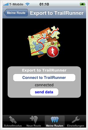
As developing a decent iPhone application is as much work as developing huge parts of TrailRunner I decided to not write my own iPhone app but to partner with one of the existing ones. This companion application you can buy in the App store is iTrail.
TrailRunner and iTrail require domestic Airport/Wifi network to transfer data from the iPhone onto your Mac.
This is how it works:
Buy iTrail
If you did not already, buy iTrail in the app store and make some route recordings.
> Website
Transfer Routes
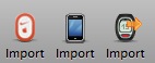 Start TrailRunner. You’ll notice a new icon in the toolbar if you are a first time user. Otherwise you can add this icon by control clicking the control bar and adding the new iPhone Icon.
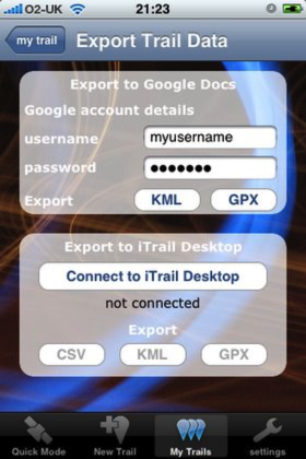
An importer pane will open on the left hand side of the main window. Follow the steps described there.
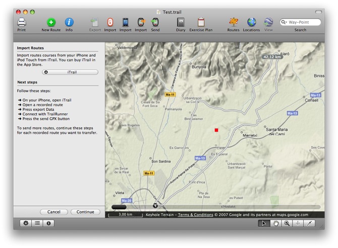
In the current version of iTrail (shown on the left), TrailRunner and iTrail Desktop are the same. This will change in the future to something like in the right screenshot (taken from a preview build of iTrail 1.7).
It is important to know that TrailRunner can not interpret the proprietary CSV file format of iTrail. The GPX file format is the one you should choose for the transfer.
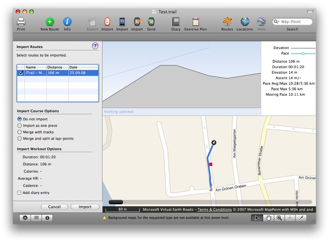
After the course was received in TrailRunner you’ll see the regular workout import pane you might already know. Choose any of the import options and probably add a diary entry for this recording.
TrailRunner and iTrail require domestic Airport/Wifi network to transfer data from the iPhone onto your Mac.
This is how it works:
Buy iTrail
If you did not already, buy iTrail in the app store and make some route recordings.
> Website
Transfer Routes
An importer pane will open on the left hand side of the main window. Follow the steps described there.
In the current version of iTrail (shown on the left), TrailRunner and iTrail Desktop are the same. This will change in the future to something like in the right screenshot (taken from a preview build of iTrail 1.7).
It is important to know that TrailRunner can not interpret the proprietary CSV file format of iTrail. The GPX file format is the one you should choose for the transfer.
After the course was received in TrailRunner you’ll see the regular workout import pane you might already know. Choose any of the import options and probably add a diary entry for this recording.
Import and Export for Garmin Edge 705
06.10.08 00:33 Filed in: Features
One of the nice things with the Garmin Edge is that you can mount the device as a Harddrive on your mac. Then within the folder you see all workouts accomplised.
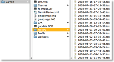 It’s pretty easy to open these in TrailRunner. Just select a bunch and drag them onto TrailRunner and you’ll see them there.
This week I implemented the other direction. TrailRunner can now write the native file format for the newer Garmin devices, with the .tcx file extension.
There are a few steps to follow and it’s very convenient after that:
> Right-click on the control bar
> Choose Cutomize Toolbar…
> Drag the Export as TCX icon into your toolbar.
Next, when you like to export a route course onto your Edge, just select the route, press the Export button and save the route into the courses folder of the edge.
That’s it.
TrailRunner 1.8 - Share your Routes
21.09.08 19:07 Filed in: Features
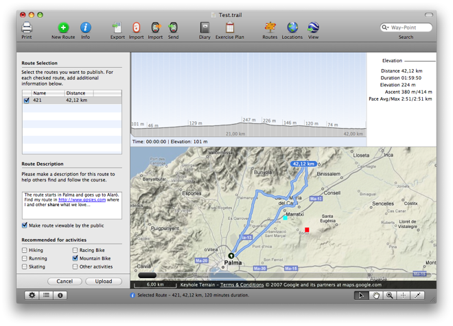
Completed the next level for the GPSies.com integration. After the download of routes from the GPSies community was recently introduced you now can share your routes with others in the GPSies community. Quick how to:
Open Route Sharing
You’ll find the new menu command under File > Share Routes.
Login
Get an account at GPSies.com and log in.
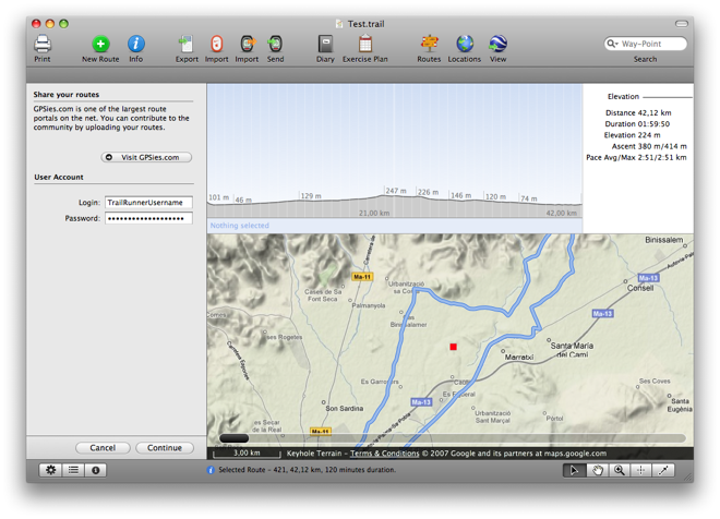
Choose Routes to Share
Select the routes you want to share by placing a check mark.
For each chosen route, enter your route description. If you’d like to reference to other websites for detail, TrailRunner will automatically detect hyperlinks.
Choose your descriptions wisely as they will help others follow the same course as you did (even with GPS devices this is still recommended)
Select a suitable activity for your suggestion and press upload.
Within the GPSies.com portal you can still refine your route descriptions at a later point. Have fun…
Download a Preview Build of TrailRunner with this feature
Open Route Sharing
You’ll find the new menu command under File > Share Routes.
Login
Get an account at GPSies.com and log in.
Choose Routes to Share
Select the routes you want to share by placing a check mark.
For each chosen route, enter your route description. If you’d like to reference to other websites for detail, TrailRunner will automatically detect hyperlinks.
Choose your descriptions wisely as they will help others follow the same course as you did (even with GPS devices this is still recommended)
Select a suitable activity for your suggestion and press upload.
Within the GPSies.com portal you can still refine your route descriptions at a later point. Have fun…
Download a Preview Build of TrailRunner with this feature
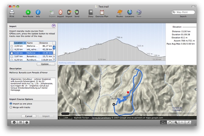
TrailRunner 1.8 - GPSies on the Run
20.09.08 19:22 Filed in: Features

The route course lookup is accessible through either the File > Find Routes Nearby command or the new toolbar-icon. A new importer pane will open on the left displaying all routes available near the current map location. Browse, check and import what you like and use TrailRunners merge and planning options to individualize what others have already explored for you.
TrailRunner 1.8 - Borderless Freedom
15.09.08 23:12 Filed in: Features
TrailRunner 1.8 is out !
Have fun and thanks for your feedback!
> Download
User Interface
Reworked the overall application design to match the current state of the art
Map loading
Although already improved much in 1.7 this now should be it.
Track editor
Selections within the profile chart, route slider, track editor and route description window are now fully synchronized.
Routes vs. Workouts
One of the biggest problems for TrailRunner newbies was, that the differences between a route and a workout / the main document and the diary wasn’t intuitively clear. So I now changed the interface to make both approaches available in the main window.
Download here: http://trailrunnerx.com/download-beta-redirect.html
NanoMaps for Mobiles
26.07.08 09:02 Filed in: Features
Images sizes for different displays
For all who do not know the resolution of their device I started a collection for common devices like the T610 on the left. You can find the list in the Library. If you did successfully export your directions onto any device that is not listed there, please leave me a note what device you are using and the resolution that fits best on its screen.
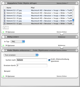
TrailRunner exports the images as jpegs. Unfortunately not all cellphones can display them (like the K610i). Therefore you first need to convert the images to the png format. Heiko noted this and has sent screenshots of his Automator Action to easily convert the images :
- Select Files from Finder
- Change Image Format to PNG
- Change Finder Object Names
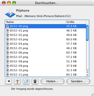
In general I expect you to transfer the NanoMaps onto your cellphone using the Bluetooth File Exchange Application. Browse your device and drag the images into its pictures directory.
TrailRunner 1.7 - Released
04.07.08 13:34 Filed in: Features
TrailRunner 1.7 is now out. Please note that TrailRunner 1.7 requires MacOS X 10.5 Leopard to run. If you are still working under 10.4 Tiger, you can use the last 1.6 release. Development for the 1.6 release will be stopped from now on.
What's new in 1.7:
Merge
Rewrote the merge elements algorithm to be more stable, faster and to support more operations to be undoable. It's not complete yet but given the fact that this is extremely complex, I am very happy with what I have learned and was able to dig out as the current core. Also reduced the geographic snap-in grid from 20 meters to 10 meters.
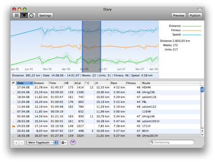
Workout History
I am at rewriting the old overall history diagram. Instead of the once fancy idea of having adaptive time intervals like "Summer 06" I now go the conservative way of weeks. The screenshot below should illustrate what I mean. As you can see the diagram type is identical to the workout analysis graph meaning you have the same analysis features.
New is the deviation background behind the line. As before, TrailRunner displays the statistical median for an interval but now gives you an idea in what value range this median lies within (see the grey background with the dotted outline)
Weblog
The weblog now also publishes a zoomed image along with the thumbnail left to the weblog entry. Click on the thumbnail to see the enlarged version. Find an example in my own weblog.
Nike+ SportBand and nikeplus.com
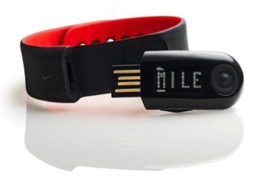
Originally I had planned to access the new Nike+ SportBand workout data much like I access an iPod. But it turned out to be impossible. But then I learned how easy it was (for me) to access a users complete workout store at nikeplus.com. The consequence? Register at nikeplus. Set goals, run competitions, put yourself into the spotlight and then download your personal data back into TrailRunner—on your Mac. It's your property. Find all this behind the Nike + Apple SportKit toolbar button.
Get the latest changes from the Release Cast
Download the latest TrailRunner 1.7 Release Download
Download the last TrailRunner 1.6 Release Download
What's new in 1.7:
Merge
Rewrote the merge elements algorithm to be more stable, faster and to support more operations to be undoable. It's not complete yet but given the fact that this is extremely complex, I am very happy with what I have learned and was able to dig out as the current core. Also reduced the geographic snap-in grid from 20 meters to 10 meters.
Workout History
I am at rewriting the old overall history diagram. Instead of the once fancy idea of having adaptive time intervals like "Summer 06" I now go the conservative way of weeks. The screenshot below should illustrate what I mean. As you can see the diagram type is identical to the workout analysis graph meaning you have the same analysis features.
New is the deviation background behind the line. As before, TrailRunner displays the statistical median for an interval but now gives you an idea in what value range this median lies within (see the grey background with the dotted outline)
Weblog
The weblog now also publishes a zoomed image along with the thumbnail left to the weblog entry. Click on the thumbnail to see the enlarged version. Find an example in my own weblog.
Nike+ SportBand and nikeplus.com
Originally I had planned to access the new Nike+ SportBand workout data much like I access an iPod. But it turned out to be impossible. But then I learned how easy it was (for me) to access a users complete workout store at nikeplus.com. The consequence? Register at nikeplus. Set goals, run competitions, put yourself into the spotlight and then download your personal data back into TrailRunner—on your Mac. It's your property. Find all this behind the Nike + Apple SportKit toolbar button.
Get the latest changes from the Release Cast
Download the latest TrailRunner 1.7 Release Download
Download the last TrailRunner 1.6 Release Download
Cheap GPS receiver alternatives
28.06.08 19:49 Filed in: Technology
One user named Rolf is using a GPS mouse for recording his course data. This might be an interesting alternative if you would not like to afford an expensive GPS device like the Garmin ForeRunner or Edge. This is how Rolf uses it:
The iBlue is a USB/Bluetooth-GPS-Mouse and can record up to 100'000 data points in any configurable time interval.
You read the recorded data off the device with an application called MacTravelRecorder.
Create a GPX file and open it with TrailRunner.
With MacTravelRecorder I can set the settings of the iBlue747 and also download tracks down to my Mac. Normally I use the settings for GoogleEarth so I can export the tracks directly into GoogleEarth, or also export the tracks into the GPX-file and open this in TrailRunner.
The iBlue 747 Bluetooth Data Logger GPS Receiver is ~$65 at amazon.
> Mac TravelRecorder
> Transystem, maker of the iBlue
I am impressed
27.04.08 19:10 Filed in: Maps
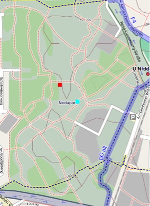
Do you also dream of a time when topographic maps are available for free and the quality would almost be better than commercial alternatives? The time has come. Left you see the region where I do most of my "home runs" on google terrain maps and right the same area on openstreetmap.org. What a detail, how nice…
TrailRunner 1.7 - Leopard only
16.03.08 13:31 Filed in: Technology

TrailRunner 1.6 - New Layout Mimic
15.03.08 22:14 Filed in: Features
Release v216 already brought the first major rewrite of the layout track and layout route mimic. v217 will bring the next level, the adjust route mimic.
Mostly important, the stupid you first have to create a network of tracks and then think of your routes limitation is now gone. All first time users have only their route in mind and don't care a straw about any conceptual limitations in TrailRunner. So I finally removed another annoying limitation: Just press the green New Route button and start creating your route while in reality you create a track and concurrently add it to the piggyback route. The Layout and calculate routes chapter in Help has a video tutorial illustrating this:
Changing the course of a route is an old, yet one of the first features, of TrailRunner — though most users might not be aware of it. It's simple: Drag any way-point that's part of the routes course onto another free way-point and reroute the route over that point. The new behavior is that while you are dragging you get a visual preview of what the result of the reroute will look like. As with the new layout engine, undo should now be fine with this operation too. Have a look:
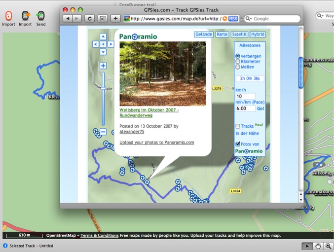
TrailRunner - GPSies - Panoramio : Get the Picture
24.02.08 21:05 Filed in: Routes
You might have already found this out but one of the niceties with the GPSies integration in TrailRunner is photos at Panoramio right along your track.
Just publish your route as a public weblog entry or directly display the route at GPSies and check the Panoramio checkbox.
Just publish your route as a public weblog entry or directly display the route at GPSies and check the Panoramio checkbox.
Help !!
09.02.08 17:04 Filed in: Conceptual
This time I'd like to place a call into the TrailRunner community. A call for your help.
In the past, TrailRunner became more and more feature rich, not yet over-loaded but pretty complex. And TrailRunner has conceptual limitations by it's nature of being freeware using free services and a single person background (me).
My development cycle goes from answering support emails, fixing bugs, developing new features, documenting features and back again.
As you might have noticed I tend to develop features with the highest request rate first. But this ignores a great number users: The first time users. And to make TrailRunner bigger and better, we need helping them to get onto the trail. And that's what I am asking your help for.
Tutorials
Currently I have set up three tutorials, one for each technical target group. But when Steve Jobs explained us all in his keynote that the Amazon Kindle will fail due to the fact that no-one is reading anymore, he was quite right. Written tutorials are good for those that take the time but nothing for a first time user. They want video tutorials. But video tutorials are double the work, or even more.
Assistance
Many software packages try to solve the learning curve problem by providing assistance like tip of the day, warning messages with the obligatory "don't show this anymore" checkbox and the glorious MS Office paper-clip assistant. I already have added warning messages on key usage trails but that's far from being perfect. I started on a tip of the day system but haven't completed this yet.
Forum
In the age of internet it looks like every software package is required to have a forum. But at least after a month you need a forum administrator — and that's me. So I ignore the whole forum demand and keep focused on my feedback mails, unless I would know there would be valuable and useful support content growing in the forum content, without my intervention being required.
All in all, my questioning is, who would like to help me out by:
Extending, refining and completing Tutorials, possibly by creating a video Tutorial.
Giving me pointers on where first time users (like you once where too) would get stuck in the application and what tips of a day would help to get further.
Making suggestions on forum topics that might help new users to get valuable information that is generated by other users, and not moderated by myself.
If you have the time and ability, please drop me a line. Didn't you not always want to use iMovie and didn't know what for… Here you go (maybe).
US Army Topographic Maps
29.01.08 00:01 Filed in: Maps
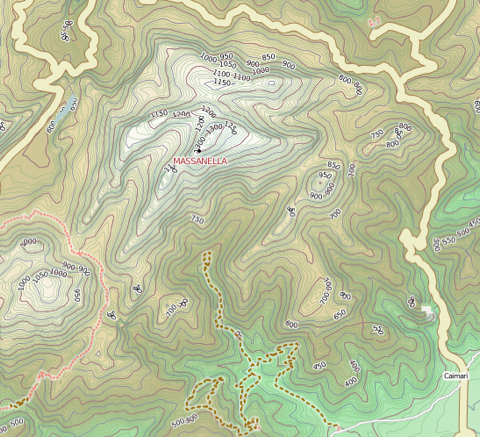
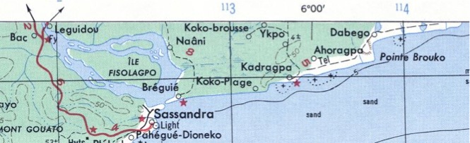 If you live outside the western countries that already offer topographic map services TrailRunner can use, you might want to take a look at the topographic map collection of Perry-Castañeda Library of the University of Texas at Austin. They provide tons of topographic maps created by the US Army. The map above depicts the Ivory Coast in West Africa, a place I've been to years ago.
It would be great if someone could tile these into a common web service format. But until that is done, you can manually add the maps to TrailRunner and calibrate them.
> US Army Map Service Topographic Maps
> Perry-Castañeda Library Map Collection
Press Reviews
26.01.08 09:30 Filed in: Gossip

June 2006 issue of UK MacFormat magazine published a two page how two get directions from your iPod. "Create maps and route plans, then transfer them to your iPod wit this ingenious piece of software". Pages 62 and 63.
October 2006 issue of the german MacLife magazine wrote a News & Trends article about TralRunner and GPS Photo linker. The article is called "Rennende GPS-Fotografen" (running GPS photographers). Page 13.
Frebruary 2006 issue of german c't magazine noted TrailRunner in its New for Mac section. Page 54 announces the new iPod Nano and below an Article about TrailRunner. "Mit TrailRunner kann man seine Laufstrecken planen".
More Press Reviews
Keeping Your Workout Fresh: MacApper.com, 01/26/08
TrailRunner 1.6 - Community and tracks nearby
20.01.08 02:05 Filed in: Features

You still might know GPSies from one of my previous posts. GPSies is a site that stores and visualizes running courses or Mountain Bike Tracks users have uploaded to share. TrailRunner now integrates with GPSies in two ways:
Display weblog tracks
Every weblog entry now has a new link that displays the attached route at GPSies. This makes it convenient for your visitors to quickly investigate the route and not just download the GPX or KML files.
Find Tracks Nearby
For the current location in your document, TrailRunner opens a new browser window and displays what GPSies has to offer for this region. To do this, use File > Show nearby tracks
When GPSies has opened, you'll find a search pane on the right that will show you routes nearby. If you have found a route that is of any interest to you, download the route. Drag the downloaded file onto the TrailRunner application icon in your dock and you can merge the new route into your main document.
I have the strong feeling I don't have to tell you how cool this is.
> http://www.gpsies.com
TrailRunner 1.6 - Improved Polar Workout Import
09.01.08 01:35 Filed in: Features
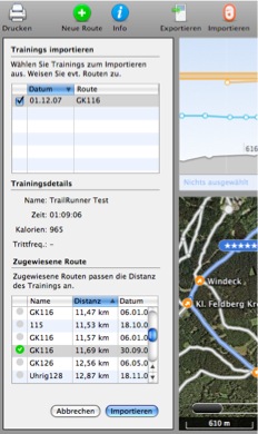
- Press the import button
- Use TrackRecord to read in your workout data
- Quit TrackRecord
- Press the continue button in TrailRunner
- Select workouts to be imported and assign routes.
Assigning a route will then merge the workout recordings with the TrailRunner route, giving you a good overlay of both.
And this also answers one of the most frequently asked questions: TrailRunner requires your Polar recordings to contain distance information. If that is not the case, the workout can't be imported. The reason is that TrailRunner is distance based and not time based. To overlay a distance based route with e.g. heart-rate information, the workout recording must be in the same unit meaning to be distance based too. This is a core concept and a time based approach will never be implemented into TrailRunner.
Have fun with another preview release:
> Download
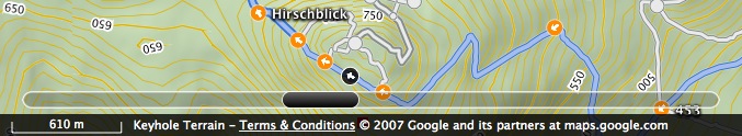
TrailRunner 1.6 - Export and Retrace
09.01.08 01:17 Filed in: Features
The next major release step will bring a highly requested and an intuitive new feature.
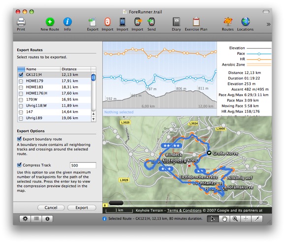
 The former is a new route export pane. It will appear on Send To GPS and Save as GPX, will let you select more than one route to be exported and has the following options:
Boundary route: The idea behind this is to get all crossings exported without exporting the whole track network. As a track network is not part of the conceptual background in GPX files, this "pseudo" route will act as a hull around the selected route. Unfortunately my Garmin ForeRunner is not able to display more than one course at a time but it might be useful in other cases.
Compression: If you export more than one route into a GPX file the amount of data might overrun your devices memory limits. Compression might help to reduce the amount. A visual preview of the selected track depicts what the compressed track looks like.
The latter new feature are track animations and a route slider. If you previously selected a checkpoint in the left hand table and used the arrow-down key to browse through the course of your route (what I do to memorize the course before I go out, even though you have electronical cheat sheets like NanoMaps and Send To GPS) TrailRunner will now retrace the course of the track segment up to the next checkpoint. Additionally, the new route slider at the bottom of the map lets you browse through the course of the route much the same way as coverflow in Leopard does with files.
If you are a thrill seeker or would like to be a cheer leader, download a nightly build here:
> Download
Enjoy!
At this point I'd like to thank everybody who gave me feedback and motivation for the TrailRunner project in the past year. The project still satisfies me very much and we'll see many more updates in the future. All the best to everybody for 2008…