TrailRunner 3.0 -- Improvements on the way
12.03.10 17:03 Filed in: Features
A quick overview on that has changed in TrailRunner 3.0:
Reworked UI and wording
To better meet the vocabulary being used in other applications, TrailRunner will no longer speak about workouts but activities.
Also activities, routes and your network of tracks are displayed in a better UI.
All application modes now come with their own dedicated toolbar at the bottom end of the window making the UI much more clearer.
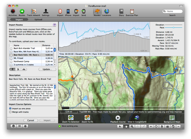
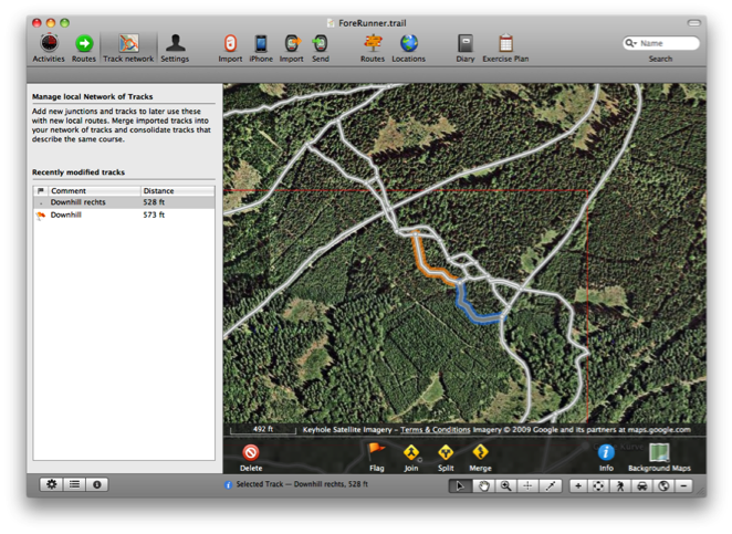
New Network of tracks editor
The new editor makes managing your network of tracks much easier. Drag selection and shift click extent selection lets you select more than one element
Operations on the action toolbar give you the toolset to effectively remove duplicate tracks and waypoints.
A list of modified tracks on the left helps you in finding out what was newly added to your network and may contain duplications to be merged into your network of tracks.
WayPoint Perimeters
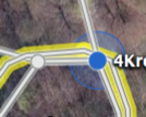 As you know, tracks can be spitted by a waypoint nearby. In previous versions of TrailRunner the maximum distance from a way-point to track to make this happen was a fixed value of 10 meters.
In the new network of tracks editor, you now see this perimeter range around selected waypoints and you can drag the border to extend the range.
This is especially useful when you have locations where great chaos lies within because many routes start and end somewhere around this spot. Now you can just increase the perimeter of one representative for this location and TrailRunner will then be able to better consolidate new elements within this area.
Better OpenStreetMap Source
Changed the Background Map to CloudMade openStreetMap Fine Line with a contour overlay.
To effectively reload all map tiles, remove the
Improved Integration with EveryTrail
 The community routes browser and importer now supports an improved API version for finding routes nearby on everytrail.com. Additionally TrailRunner hilights not only the location of routes nearby but also displays the tracks. So you now easily can view what courses the routes have.
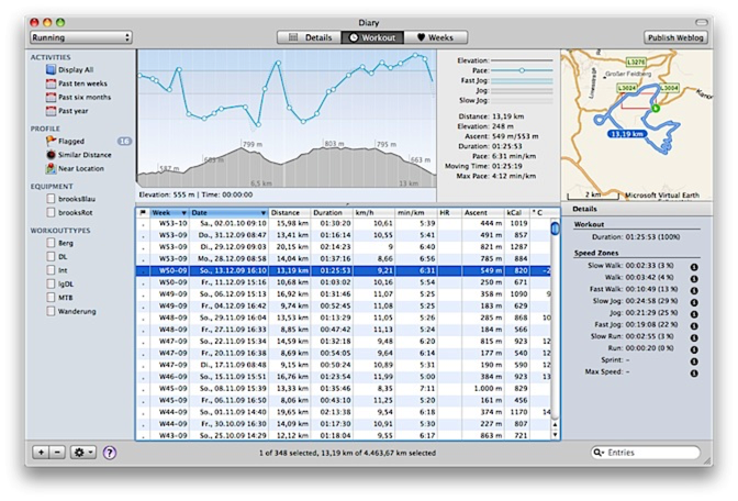
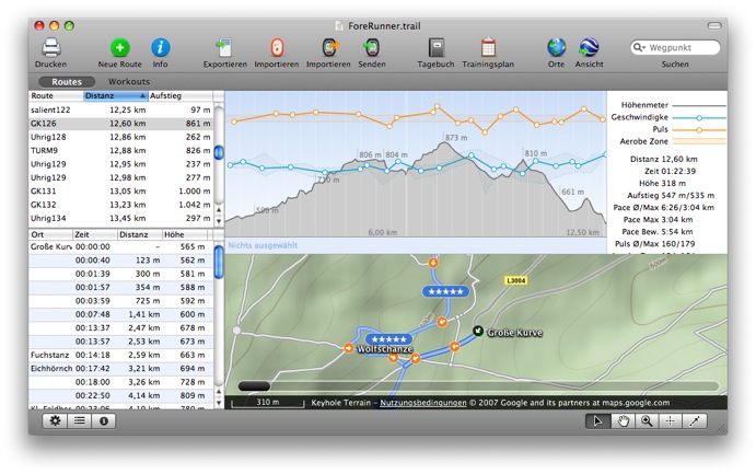
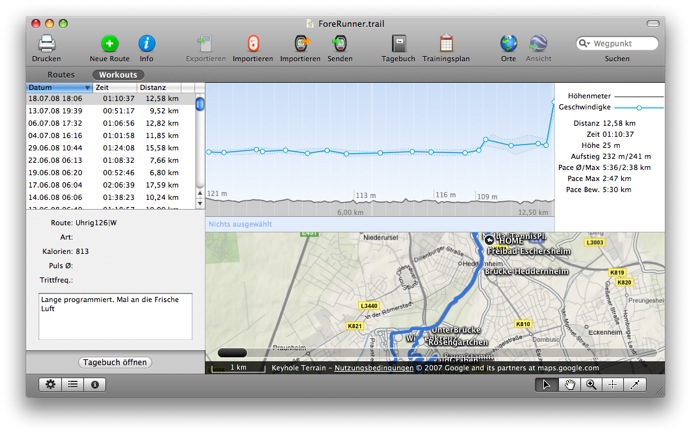
Improved Diary
The diary window now displays a map and more statistical information on the selected activity.
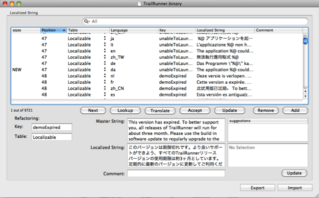
Simplified process of localization
Over the years, the number of strings requiring localization grew to a huge number. A new database based application now helps localizers manage and update the localizations with a very easy interface that also contains a ToDo list and automatic pre-translation provided by translate.google.com
If you would like to help out with an updated or even new localization, please contact me.
QuickGuide for TrailRunner 3.0
The QuickGuide shows you all main features of the application. Great for testing everything out:
> QuickGuide
Reworked UI and wording
To better meet the vocabulary being used in other applications, TrailRunner will no longer speak about workouts but activities.
Also activities, routes and your network of tracks are displayed in a better UI.
All application modes now come with their own dedicated toolbar at the bottom end of the window making the UI much more clearer.
New Network of tracks editor
The new editor makes managing your network of tracks much easier. Drag selection and shift click extent selection lets you select more than one element
Operations on the action toolbar give you the toolset to effectively remove duplicate tracks and waypoints.
A list of modified tracks on the left helps you in finding out what was newly added to your network and may contain duplications to be merged into your network of tracks.
WayPoint Perimeters
In the new network of tracks editor, you now see this perimeter range around selected waypoints and you can drag the border to extend the range.
This is especially useful when you have locations where great chaos lies within because many routes start and end somewhere around this spot. Now you can just increase the perimeter of one representative for this location and TrailRunner will then be able to better consolidate new elements within this area.
Better OpenStreetMap Source
Changed the Background Map to CloudMade openStreetMap Fine Line with a contour overlay.
To effectively reload all map tiles, remove the
Improved Integration with EveryTrail
Improved Diary
The diary window now displays a map and more statistical information on the selected activity.
Simplified process of localization
Over the years, the number of strings requiring localization grew to a huge number. A new database based application now helps localizers manage and update the localizations with a very easy interface that also contains a ToDo list and automatic pre-translation provided by translate.google.com
If you would like to help out with an updated or even new localization, please contact me.
QuickGuide for TrailRunner 3.0
The QuickGuide shows you all main features of the application. Great for testing everything out:
> QuickGuide
TrailRunner 2.1v468 -- Topographic maps for Norway
10.12.09 22:00 Filed in: Maps
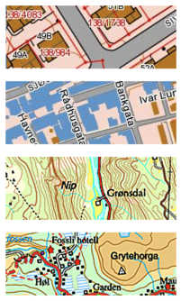
As you can see in the depicted screenshots, the quality is phenomenal.
The Map data goes from a National Map scale down to a very detailed map with properties, buildings and roads.
To view the map data, switch to the openStreetMap source and then zoom in somewhere in Norway, TrailRunner will automatically select the new source and display the background map.
> Norwegian Mapping Authority
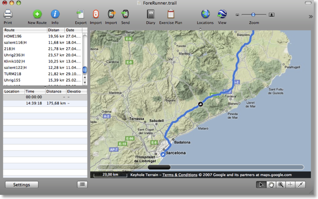
TopOSM -- topografic maps for Massachusetts, USA
03.10.09 10:19 Filed in: Technology
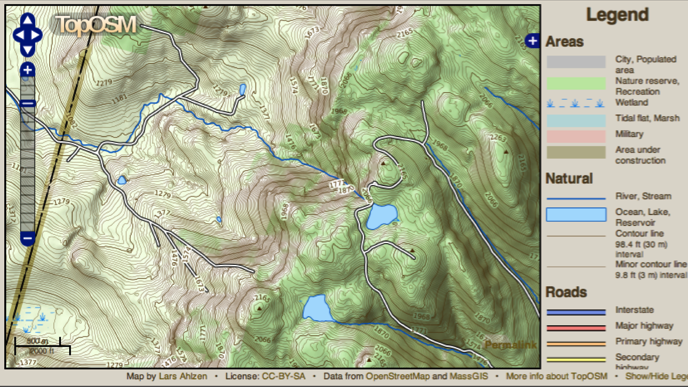
Vidar pointed me to this beautiful map source that — unfortuanetly — is limited to Massachusetts, USA. The map is an interesting montage of several layers and data sources Lars Ahlzen has accomplished.
If you choose the openStreetMap as your background map in TrailRunner and view the area covered by this map server, TrailRunner now uses this source.
Read more about this project:
> What is TopOSM
> TopOSM online viever
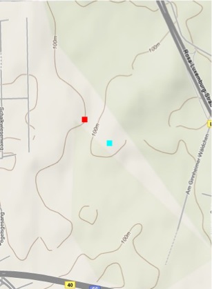
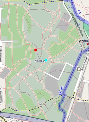
DTK Maps - Cutting Edge
03.02.09 08:49 Filed in: Technology
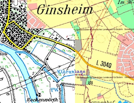
The funny thing in this picture is that I thought the left map was originally a scanned paper map and the right map was a digital vector map. That could still be true but as you can see with the word "Kläranlage" in the middle of the maps, the word is perfectly aligned on both sources.
Looks like god even planned the locations for clarification plants when he created the world.
Detailed Bike maps from opencyclemap.org
15.11.08 00:01 Filed in: Maps
I have updated the opencyclemap.org data source, as the openStreemap alternative is now hosted on a faster server.
If you didn’t know yet, the cycle map is based on the very same data as the OpenStreetMap project but uses a specialized map renderer for outdoor activities. At low zoom levels it is intended for overviews of the National Cycle Network; at higher zoom levels it should help with planning which streets to cycle on.
The new maps now display a elevation contours and hill coloring and have cycle lanes marked on streets within cities.
You might want to reload your maps if you want TrailRunner not to display the old cached imagery. You can either use File > Consolidate > Reload Background Maps or remove the whole cache directory from your home directory under yourHome/Library/Application Support/TrailRunner/GeoTiles/openstreetmap.org
> openstreetmap.org
> opencyclemap.org
TrailRunner 1.8 - Borderless Freedom
15.09.08 23:12 Filed in: Features
TrailRunner 1.8 is out !
Have fun and thanks for your feedback!
> Download
User Interface
Reworked the overall application design to match the current state of the art
Map loading
Although already improved much in 1.7 this now should be it.
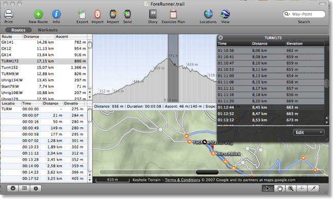
Track editor
Selections within the profile chart, route slider, track editor and route description window are now fully synchronized.
Routes vs. Workouts
One of the biggest problems for TrailRunner newbies was, that the differences between a route and a workout / the main document and the diary wasn’t intuitively clear. So I now changed the interface to make both approaches available in the main window.
Download here: http://trailrunnerx.com/download-beta-redirect.html
Have fun and thanks for your feedback!
> Download
User Interface
Reworked the overall application design to match the current state of the art
Map loading
Although already improved much in 1.7 this now should be it.
Track editor
Selections within the profile chart, route slider, track editor and route description window are now fully synchronized.
Routes vs. Workouts
One of the biggest problems for TrailRunner newbies was, that the differences between a route and a workout / the main document and the diary wasn’t intuitively clear. So I now changed the interface to make both approaches available in the main window.
Download here: http://trailrunnerx.com/download-beta-redirect.html
Import directions from maps.google
14.08.10 20:06 Filed in: Technology
If you want to import a route planned with maps.google.com into TrailRunner, follow these steps:
Goto maps.google.com and use the Get Directions tab to plan your course.
Click the Link to this page link.
In the Paste link in email or IM edit field, append &output=kml to the end of the url (with no blank inbetween)
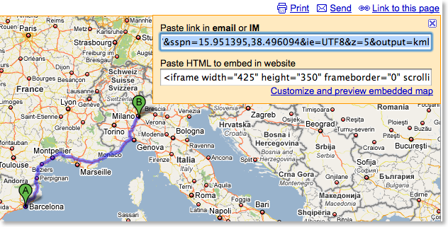
Copy the whole URL and paste it into the address bar. Press the return key.
A kml file will now download. Drag the maps.kml file onto TrailRunner or the main window. The course importer will open.
More convenient alternatives:
Convert Google Maps Data to GPX
> GMapToGPX
> GMapToGPX (German)
Goto maps.google.com and use the Get Directions tab to plan your course.
Click the Link to this page link.
In the Paste link in email or IM edit field, append &output=kml to the end of the url (with no blank inbetween)
Copy the whole URL and paste it into the address bar. Press the return key.
A kml file will now download. Drag the maps.kml file onto TrailRunner or the main window. The course importer will open.
More convenient alternatives:
Convert Google Maps Data to GPX
> GMapToGPX
> GMapToGPX (German)
I am impressed
27.04.08 19:10 Filed in: Maps
Do you also dream of a time when topographic maps are available for free and the quality would almost be better than commercial alternatives? The time has come. Left you see the region where I do most of my "home runs" on google terrain maps and right the same area on openstreetmap.org. What a detail, how nice…
US Army Topographic Maps
29.01.08 00:01 Filed in: Maps
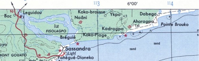 If you live outside the western countries that already offer topographic map services TrailRunner can use, you might want to take a look at the topographic map collection of Perry-Castañeda Library of the University of Texas at Austin. They provide tons of topographic maps created by the US Army. The map above depicts the Ivory Coast in West Africa, a place I've been to years ago.
It would be great if someone could tile these into a common web service format. But until that is done, you can manually add the maps to TrailRunner and calibrate them.
> US Army Map Service Topographic Maps
> Perry-Castañeda Library Map Collection
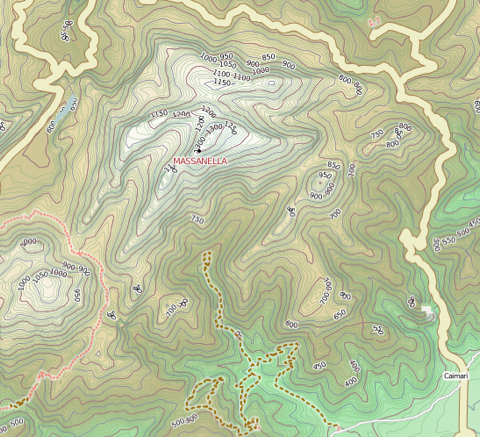
TrailRunner SneakPeek — Contour Overlay and Terrain Map Source
02.12.07 13:37 Filed in: Maps
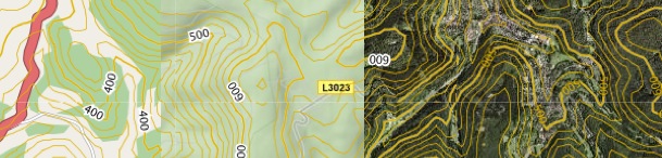
Today I added a contour layer to background maps. The contour data comes from the same USGS data source as the already known elevation download. But the transparent overlay is something being calculated and provided by Jonathan Stott from www.earthtools.org.
Earthtools is a cool service anyway. Hopefully it will stay free for a long time. As long as it is, enjoy the contours.
The display settings you'll find under Document Settings > Additional Settings > Contour : Show/Hide
The examples above show a region with the contour overlay applied to three background map sources. On the right with satellite imagery and left with openstreetmap.org. As a sidenote I realized that openstreetmap really gets a momentum. I am very pleased for the quality and detail the service now offers. As maps at openstreetmap.org change often, please regularly empty your map cache.
File > Consolidate > Empty Caches
The other news are terrain maps from Google. As you can see in the middle image, also with overlay contours applied.
> www.earthtools.org
> www.openstreetmap.org
> maps.google.com