weblog
Import directions from maps.google
14.08.10 20:06 Filed in: Technology
If you want to import a route planned with maps.google.com into TrailRunner, follow these steps:
Goto maps.google.com and use the Get Directions tab to plan your course.
Click the Link to this page link.
In the Paste link in email or IM edit field, append &output=kml to the end of the url (with no blank inbetween)
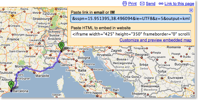
Copy the whole URL and paste it into the address bar. Press the return key.
A kml file will now download. Drag the maps.kml file onto TrailRunner or the main window. The course importer will open.
More convenient alternatives:
Convert Google Maps Data to GPX
> GMapToGPX
> GMapToGPX (German)
Goto maps.google.com and use the Get Directions tab to plan your course.
Click the Link to this page link.
In the Paste link in email or IM edit field, append &output=kml to the end of the url (with no blank inbetween)
Copy the whole URL and paste it into the address bar. Press the return key.
A kml file will now download. Drag the maps.kml file onto TrailRunner or the main window. The course importer will open.
More convenient alternatives:
Convert Google Maps Data to GPX
> GMapToGPX
> GMapToGPX (German)
TrailRunner 1.7 - Released
04.07.08 13:34 Filed in: Features
TrailRunner 1.7 is now out. Please note that TrailRunner 1.7 requires MacOS X 10.5 Leopard to run. If you are still working under 10.4 Tiger, you can use the last 1.6 release. Development for the 1.6 release will be stopped from now on.
What's new in 1.7:
Merge
Rewrote the merge elements algorithm to be more stable, faster and to support more operations to be undoable. It's not complete yet but given the fact that this is extremely complex, I am very happy with what I have learned and was able to dig out as the current core. Also reduced the geographic snap-in grid from 20 meters to 10 meters.
Workout History
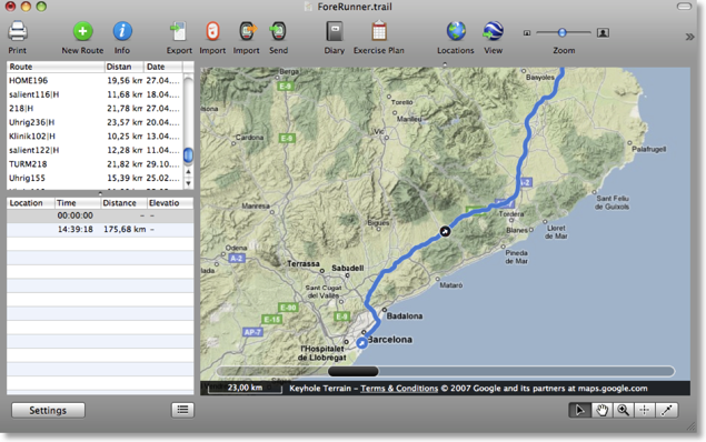
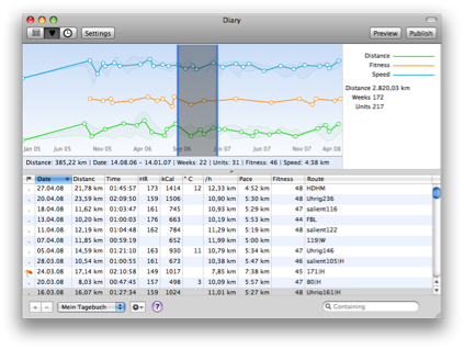
I am at rewriting the old overall history diagram. Instead of the once fancy idea of having adaptive time intervals like "Summer 06" I now go the conservative way of weeks. The screenshot below should illustrate what I mean. As you can see the diagram type is identical to the workout analysis graph meaning you have the same analysis features.
New is the deviation background behind the line. As before, TrailRunner displays the statistical median for an interval but now gives you an idea in what value range this median lies within (see the grey background with the dotted outline)
Weblog
The weblog now also publishes a zoomed image along with the thumbnail left to the weblog entry. Click on the thumbnail to see the enlarged version. Find an example in my own weblog.
Nike+ SportBand and nikeplus.com
Originally I had planned to access the new Nike+ SportBand workout data much like I access an iPod. But it turned out to be impossible. But then I learned how easy it was (for me) to access a users complete workout store at nikeplus.com. The consequence? Register at nikeplus. Set goals, run competitions, put yourself into the spotlight and then download your personal data back into TrailRunner—on your Mac. It's your property. Find all this behind the Nike + Apple SportKit toolbar button.
Get the latest changes from the Release Cast
Download the latest TrailRunner 1.7 Release Download
Download the last TrailRunner 1.6 Release Download
What's new in 1.7:
Merge
Rewrote the merge elements algorithm to be more stable, faster and to support more operations to be undoable. It's not complete yet but given the fact that this is extremely complex, I am very happy with what I have learned and was able to dig out as the current core. Also reduced the geographic snap-in grid from 20 meters to 10 meters.
Workout History
I am at rewriting the old overall history diagram. Instead of the once fancy idea of having adaptive time intervals like "Summer 06" I now go the conservative way of weeks. The screenshot below should illustrate what I mean. As you can see the diagram type is identical to the workout analysis graph meaning you have the same analysis features.
New is the deviation background behind the line. As before, TrailRunner displays the statistical median for an interval but now gives you an idea in what value range this median lies within (see the grey background with the dotted outline)
Weblog
The weblog now also publishes a zoomed image along with the thumbnail left to the weblog entry. Click on the thumbnail to see the enlarged version. Find an example in my own weblog.
Nike+ SportBand and nikeplus.com
Originally I had planned to access the new Nike+ SportBand workout data much like I access an iPod. But it turned out to be impossible. But then I learned how easy it was (for me) to access a users complete workout store at nikeplus.com. The consequence? Register at nikeplus. Set goals, run competitions, put yourself into the spotlight and then download your personal data back into TrailRunner—on your Mac. It's your property. Find all this behind the Nike + Apple SportKit toolbar button.

Get the latest changes from the Release Cast
Download the latest TrailRunner 1.7 Release Download
Download the last TrailRunner 1.6 Release Download
TrailRunner - GPSies - Panoramio : Get the Picture
24.02.08 21:05 Filed in: Routes
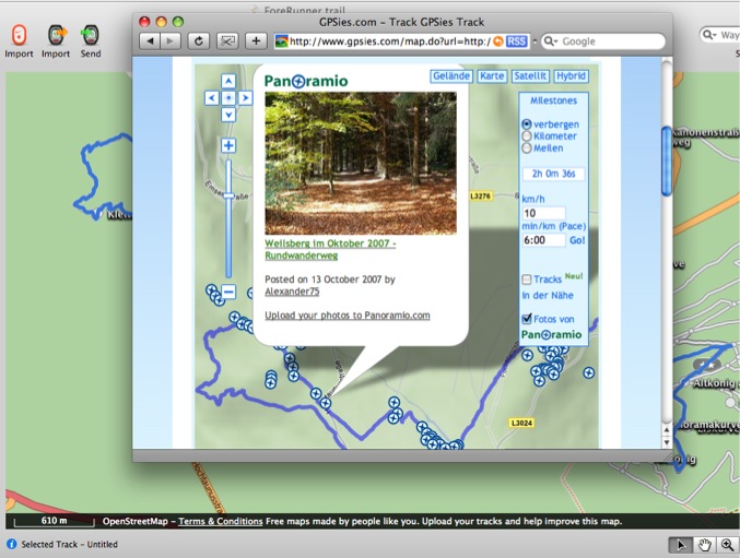
You might have already found this out but one of the niceties with the GPSies integration in TrailRunner is photos at Panoramio right along your track.
Just publish your route as a public weblog entry or directly display the route at GPSies and check the Panoramio checkbox.
Just publish your route as a public weblog entry or directly display the route at GPSies and check the Panoramio checkbox.
TrailRunner 1.6 - Community and tracks nearby
20.01.08 02:05 Filed in: Features

You still might know GPSies from one of my previous posts. GPSies is a site that stores and visualizes running courses or Mountain Bike Tracks users have uploaded to share. TrailRunner now integrates with GPSies in two ways:
Display weblog tracks
Every weblog entry now has a new link that displays the attached route at GPSies. This makes it convenient for your visitors to quickly investigate the route and not just download the GPX or KML files.
Find Tracks Nearby
For the current location in your document, TrailRunner opens a new browser window and displays what GPSies has to offer for this region. To do this, use File > Show nearby tracks
When GPSies has opened, you'll find a search pane on the right that will show you routes nearby. If you have found a route that is of any interest to you, download the route. Drag the downloaded file onto the TrailRunner application icon in your dock and you can merge the new route into your main document.
I have the strong feeling I don't have to tell you how cool this is.
> http://www.gpsies.com