TrailRunner 2.1v468 -- Topographic maps for Norway
10.12.09 22:00
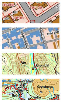
As you can see in the depicted screenshots, the quality is phenomenal.
The Map data goes from a National Map scale down to a very detailed map with properties, buildings and roads.
To view the map data, switch to the openStreetMap source and then zoom in somewhere in Norway, TrailRunner will automatically select the new source and display the background map.
> Norwegian Mapping Authority
Detailed Bike maps from opencyclemap.org
15.11.08 00:01
I have updated the opencyclemap.org data source, as the openStreemap alternative is now hosted on a faster server.
If you didn’t know yet, the cycle map is based on the very same data as the OpenStreetMap project but uses a specialized map renderer for outdoor activities. At low zoom levels it is intended for overviews of the National Cycle Network; at higher zoom levels it should help with planning which streets to cycle on.
The new maps now display a elevation contours and hill coloring and have cycle lanes marked on streets within cities.
You might want to reload your maps if you want TrailRunner not to display the old cached imagery. You can either use File > Consolidate > Reload Background Maps or remove the whole cache directory from your home directory under yourHome/Library/Application Support/TrailRunner/GeoTiles/openstreetmap.org
> openstreetmap.org
> opencyclemap.org
I am impressed
27.04.08 19:10
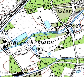
Do you also dream of a time when topographic maps are available for free and the quality would almost be better than commercial alternatives? The time has come. Left you see the region where I do most of my "home runs" on google terrain maps and right the same area on openstreetmap.org. What a detail, how nice…
US Army Topographic Maps
29.01.08 00:01
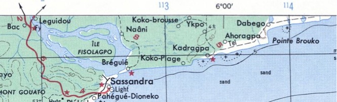 If you live outside the western countries that already offer topographic map services TrailRunner can use, you might want to take a look at the topographic map collection of Perry-Castañeda Library of the University of Texas at Austin. They provide tons of topographic maps created by the US Army. The map above depicts the Ivory Coast in West Africa, a place I've been to years ago.
It would be great if someone could tile these into a common web service format. But until that is done, you can manually add the maps to TrailRunner and calibrate them.
> US Army Map Service Topographic Maps
> Perry-Castañeda Library Map Collection
TrailRunner SneakPeek — Contour Overlay and Terrain Map Source
02.12.07 13:37
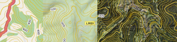
Today I added a contour layer to background maps. The contour data comes from the same USGS data source as the already known elevation download. But the transparent overlay is something being calculated and provided by Jonathan Stott from www.earthtools.org.
Earthtools is a cool service anyway. Hopefully it will stay free for a long time. As long as it is, enjoy the contours.
The display settings you'll find under Document Settings > Additional Settings > Contour : Show/Hide
The examples above show a region with the contour overlay applied to three background map sources. On the right with satellite imagery and left with openstreetmap.org. As a sidenote I realized that openstreetmap really gets a momentum. I am very pleased for the quality and detail the service now offers. As maps at openstreetmap.org change often, please regularly empty your map cache.
File > Consolidate > Empty Caches
The other news are terrain maps from Google. As you can see in the middle image, also with overlay contours applied.
> www.earthtools.org
> www.openstreetmap.org
> maps.google.com
MapDiscovery 0.5 — Topo Browser
29.12.06 18:22

GeoServer NRW
17.12.06 12:24
> PROJ.4 - Cartographic Projections Library
Mapa topografic de Catalunya
15.11.06 20:25
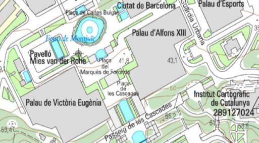
One recent WMS discovery will extend the TrailRunner maps download by maps from Catalunya (Spain). The Institut Cartografic de Catalunya (ICC) provides maps in various resolutions, down to 1:5000. This is by far (yet) the best map source I know of.
If you know other open WMS Servers with good material, please drop me a line.