How does TrailRunner mini import and export the GPX file format
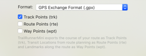
Within that format there is a conceptual difference between three types of point information:
- Track-Points:
this is a raw recording representing a course. TrailRunner mini creates track-points as a result of a calculated route (the course you see on the map) - Route-Points:
: this represents a stop point on a route and is represented as a transit location (routing pin) in TrailRunner mini. Given two transit locations, TrailRunner mini calculates a track between these using the OpenStreetMap Network. - Way-Points:
this represents a landmark in TrailRunner mini.
Whenever you export files from external sources and import them in TrailRunner mini, try to keep the data straight within the expectations of TrailRunner mini. Some applications may export tracks as a series of wpt-tags which leads to serious misunderstandings within TrailRunner mini.
There are some type conversion tools out there that may help. Like http://www.gpsbabel.org
When you export routes in the GPX format to be displayed on other devices, the same applies. Some apps may not make a difference between track/route and way-points and may display all at the same time. To avoid this, you most likely want to export your route containing trackPoints only.
Read more:
• What are landmarks and waypoints?
How can I split a route or concatenate fragments?
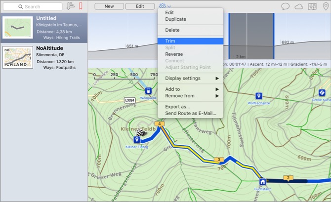
Trim
Select a route and also select a range in the elevation chart. Then choose the command to trim the route to the selection in the chart.
Split
Select a route and also select a location in the elevation chart. Then choose the command to split the route at the selection into two route fragments.
Reverse
Select a route and choose the command to reverse the course direction. In other words to make the end point the new start.
Concatenate
Select two route fragments and choose the command to join the two fragments into one concatenated route.
Adjust starting point
Select a route, preferably a round trip, and select a location in the chart. Then choose the command to set the starting point of the round trip to the select position making the old start point a simple transit location on the course of the resulting route.
The elevation data download looks to be very inaccurate
Description: TrailRunner mini downloads elevation data from a source that is based on the data provided by the NASA's Shuttle Radar Topography Mission (SRTM), which is a satellite scan of the earth surface. The resolution of the scan is about 30 meters (98 feet) in the more popular areas of the word and 90 meters elsewhere.
What could happen now is that when your GPS device made a location recording that is not very accurate, the position may hit a spot where the actual altitude differs by a large amount to what the real position would describe. For example the false position recording may not describe the path you're on but the neighboring tree top, house roof or cliff top.
This may lead to crazy point to point slopes of 30% and more. So TrailRunner mini filters out such implausible elevation data as good as it can. Otherwise all the cumulative ascend and descent data would be far of plausible values. This filter also takes place for imported files that need no elevation data download but also contain crazy point to point slopes.
Please understand that the root cause to all this is the false GPS point recording in combination with a possible lack of resolution of SRTM data. TrailRunner mini can't guess what's right, but can easily remove what is obviously wrong.

Do you really buy rainforest from TrailRunner mini sales?

You can read more about the project here: Tropica-Verde
Update: Thanks to everybody who has bought a license for TrailRunner mini. The rainforest project has received the amounts to preserve approx. 30108 qm of tropical rainforest in Costa Rica.
Can you add more map sources?
Explanation: TrailRunner mini is based on the OpenStreetMap project. When you create routes, TrailRunner mini follows a hidden network of trails and streets that is based on OpenStreetMap data. The same data is being used to render the visible map. Would I add different map sources like Google Maps, the trail or street may be visible to you but you still cannot use it within the routing editor. This would be very frustrating and therefore I will not add this feature to TrailRunner mini — just because the App is supposed to be a simple route planning tool and no professional mapping solution.
Hint: But what you can do is to contribute to the OpenStreetMap project and fix the problem at its root.
Update: In recent builds of TrailRunner mini and RaceBunny you can choose between different map Sources. But please understand that these still are based on the openStreetMap project data and therefore cover the same level of detail, though the design may differ.
Expert Hint: When you click on the map toolbar icon in TrailRunner mini, select the option to display more map sources. Then choose any of the available. But please understand that these may display different data than the routing editor can display. If that is the case you may use the off-road routing feature to follow these ways.
What file formats can I import in TrailRunner mini
GPS eXchange Format (GPX) this is the most versatile file format for data exchange between any devices. The TrailRunner dropbox import and export is fully based on that format.
Garmin Training Center Format (TCX) this file format is the native exchange format for Garmin devices. TrailRunner mini can import the route data of these file types.
Google Earth (KML) This file format is the native exchange format for Google Earth. TrailRunner mini can read and write this format.
Training Peaks (PWX) this file format is being used for the Timex Global Trainer devices. TrailRunner mini can only import this file type.
Fuel my run. Please note that I create TrailRunner mini in my spare-time. So if you have suggestions, questions or trouble importing a file, contact me directly via application feedback. If you like TrailRunner mini, please spend some stars on the AppStore review. Have fun.
Speed Histogram
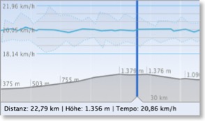
The white vertical lines represent split intervals. These depend on the distance of your recording and may be 500, 1000 or more meters each.
The blue horizontal line with the white circles displays your average speed within that split interval.
The gray area around the blue line describes the lowest and highest speed ranges within a split interval. This means that your speed was always within the gray area whereas your average speed followed the blue line.
When you select a spot, the lower information displays the absolute speed there, whereas the selection of a horizontal range displays the average within the selection.
When you click into the graph, a measure scale overlay appears displaying a grid to compare speed values within the overall recording.
Why do maps sometimes switch to satellite and roads?
Background: Not all map sources are available at all resolutions and in all areas of the world. So if the resolutions range of geographical coverage for a map source is exceeded, TrailRunner will display the best logical match it can find. For high resolutions this is satellite and for low resolutions this is roads.