

TrailRunner Mini

Real trails. Great adventures.

TrailRunner Mini is built for runners, hikers, cyclists and mountain bikers who want to discover ways beyond the main routes.

TrailRunner Mini is the best route planning app for Apple MacBook, iMac, iPad and iPhone.
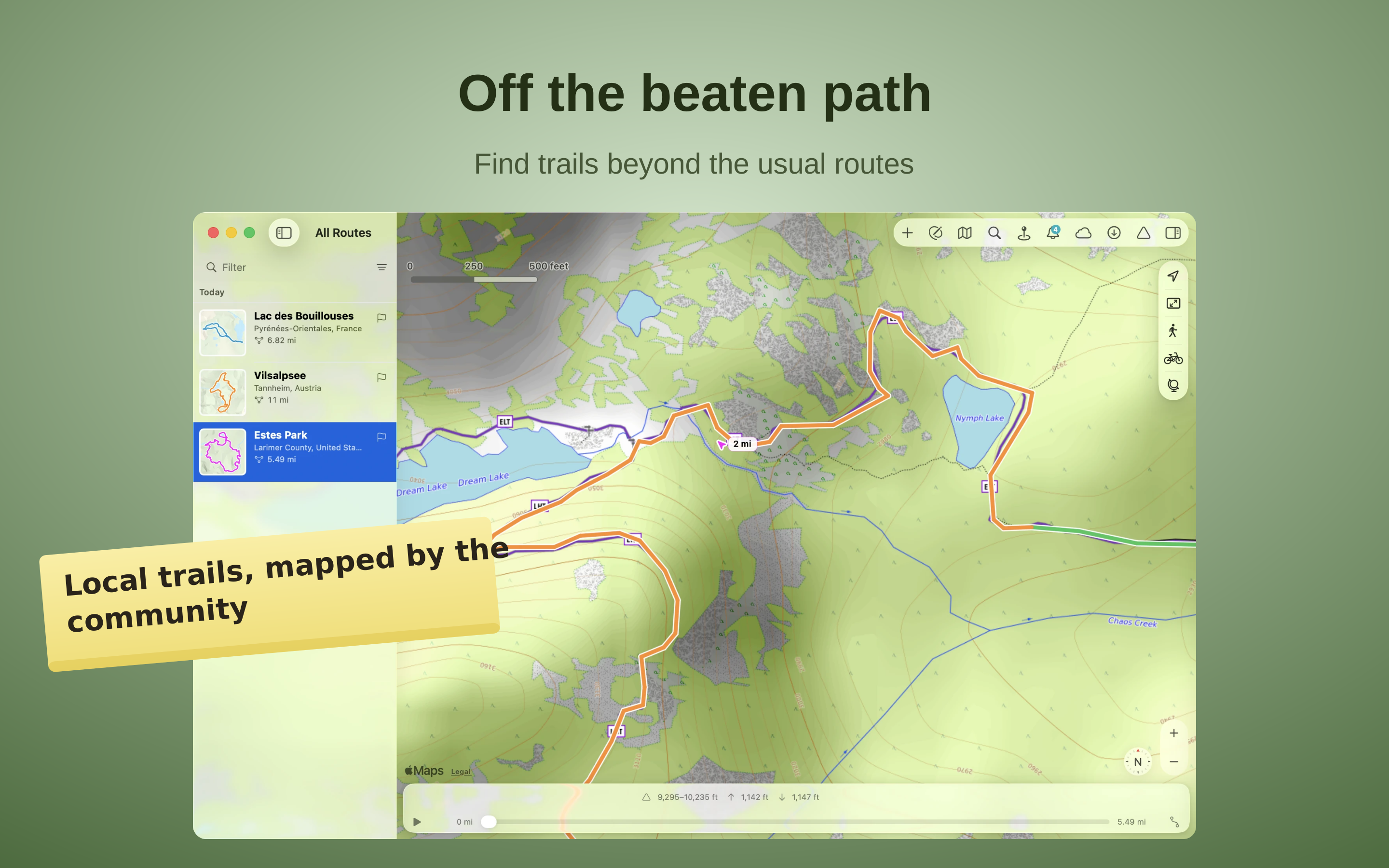
Off the beaten path

Off the beaten path

TrailRunner Mini plans routes on OpenStreetMap — a map cared for by people who know their region. Discover marked hiking trails, singletrack and nature paths away from the main routes. Hillshade and contour lines show the terrain and make it easier to find your way.
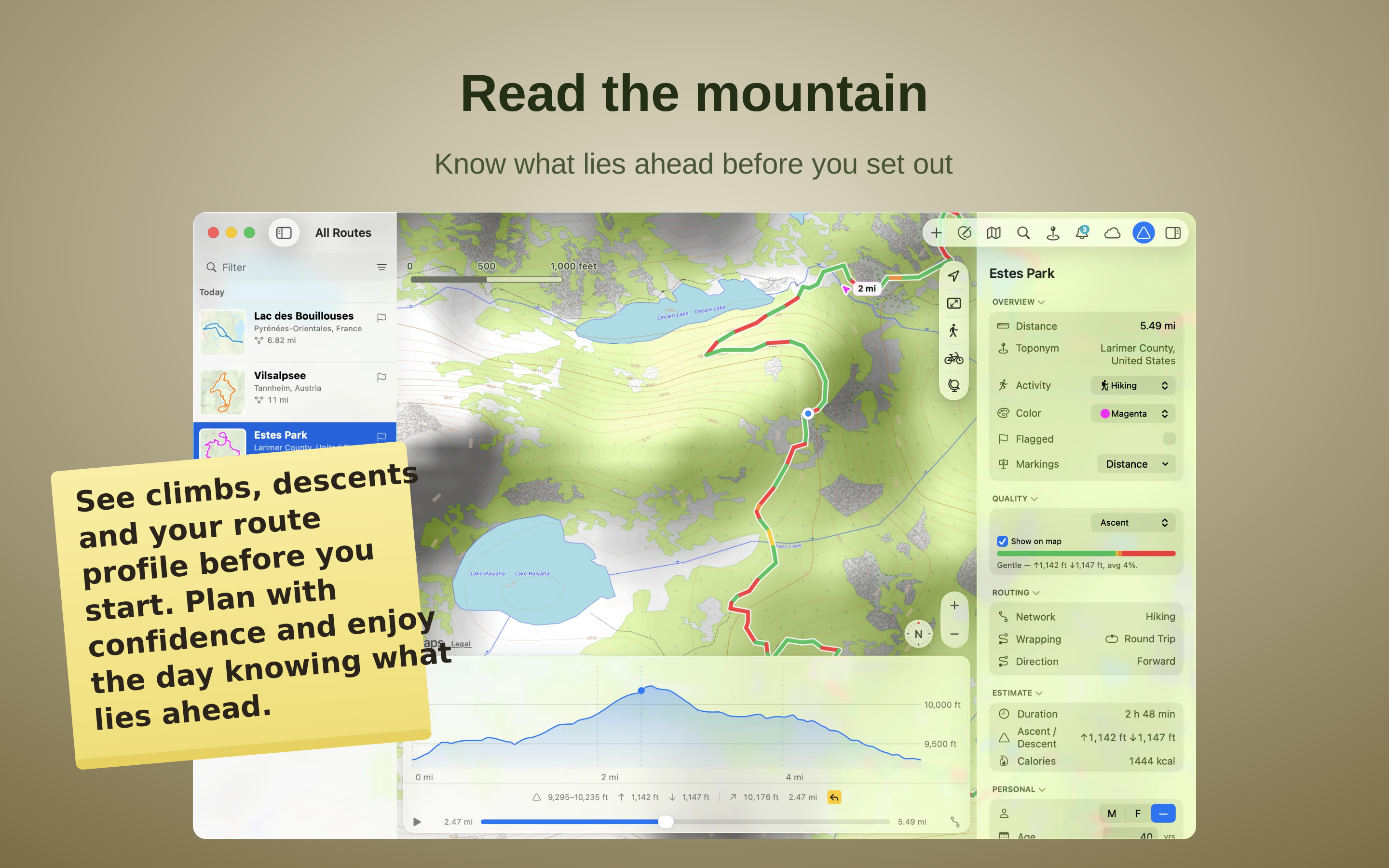
Read the mountain

Read the mountain

Read the mountain before you set out — and plan ahead. Every route comes with a full elevation profile: climb and descent in metres, the highest and lowest points, and how steep each stretch runs. As you build a route the climb adds up live, and a bar shows how much is flat, rolling or steep — so you shape exactly the effort you want, and scrub along the profile to see where it rises and falls.
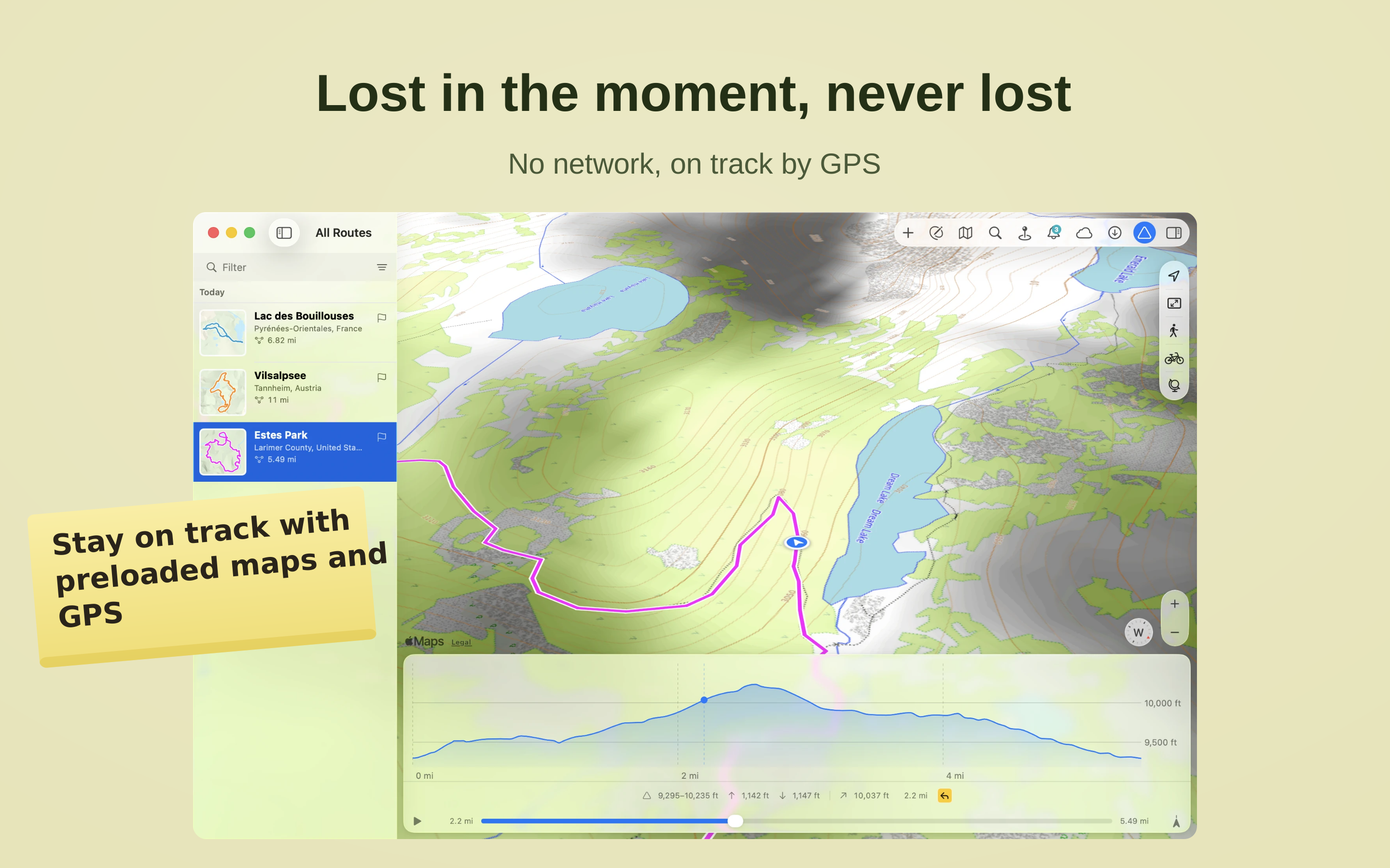
Lost in the moment, never lost

Lost in the moment, never lost

Download a region in advance — the map and navigation keep working even when there's no more mobile signal and only GPS still knows where you are.
Follow the trail signs

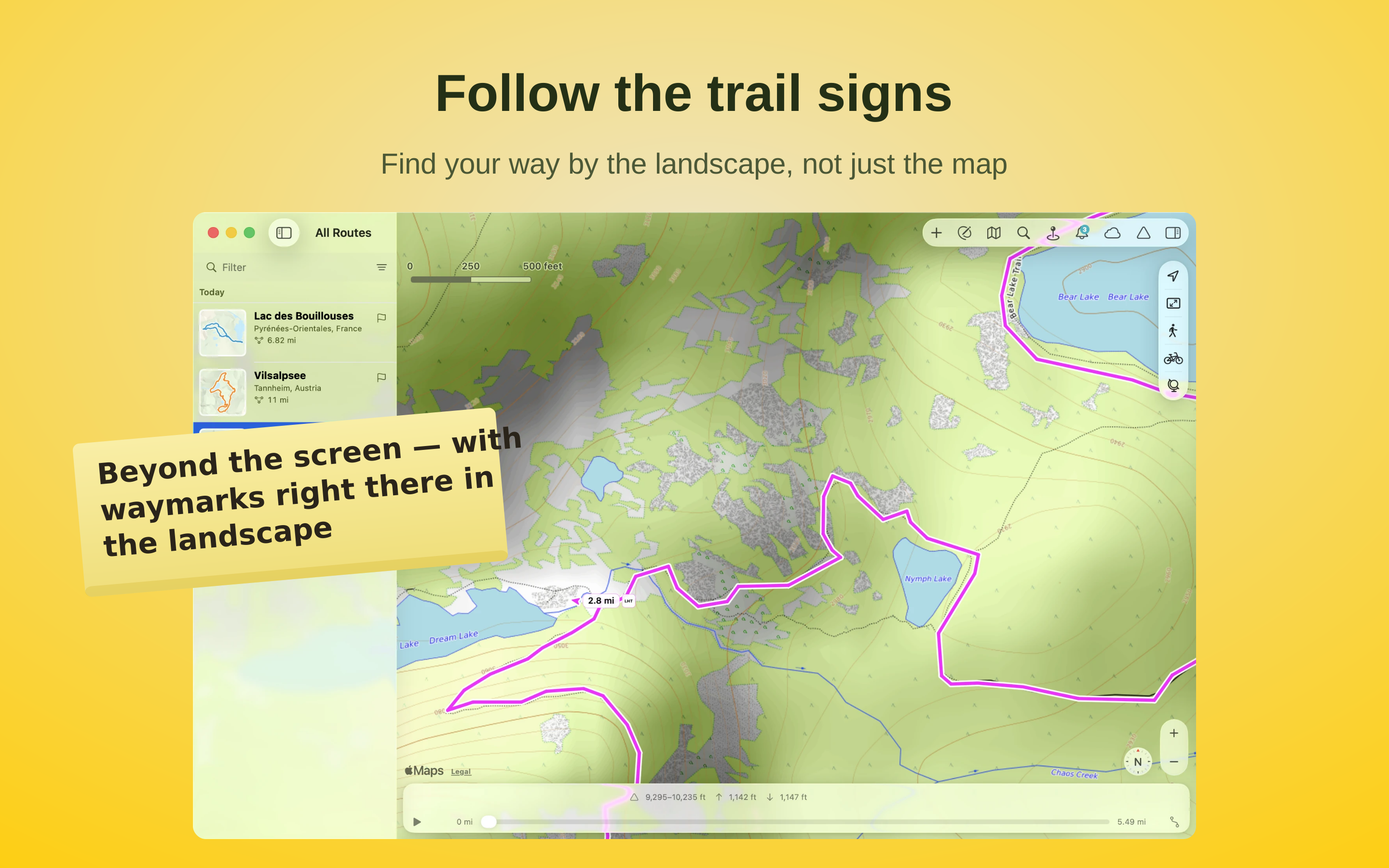
Follow the trail signs

Follow the official waymarks with their distinctive colours and symbols. Where they're recorded in the official trail network, TrailRunner Mini shows the same markings you see out on the trail. So at every junction you can tell at a glance whether to keep following the marked trail or turn onto another path.
Maps that show the terrain

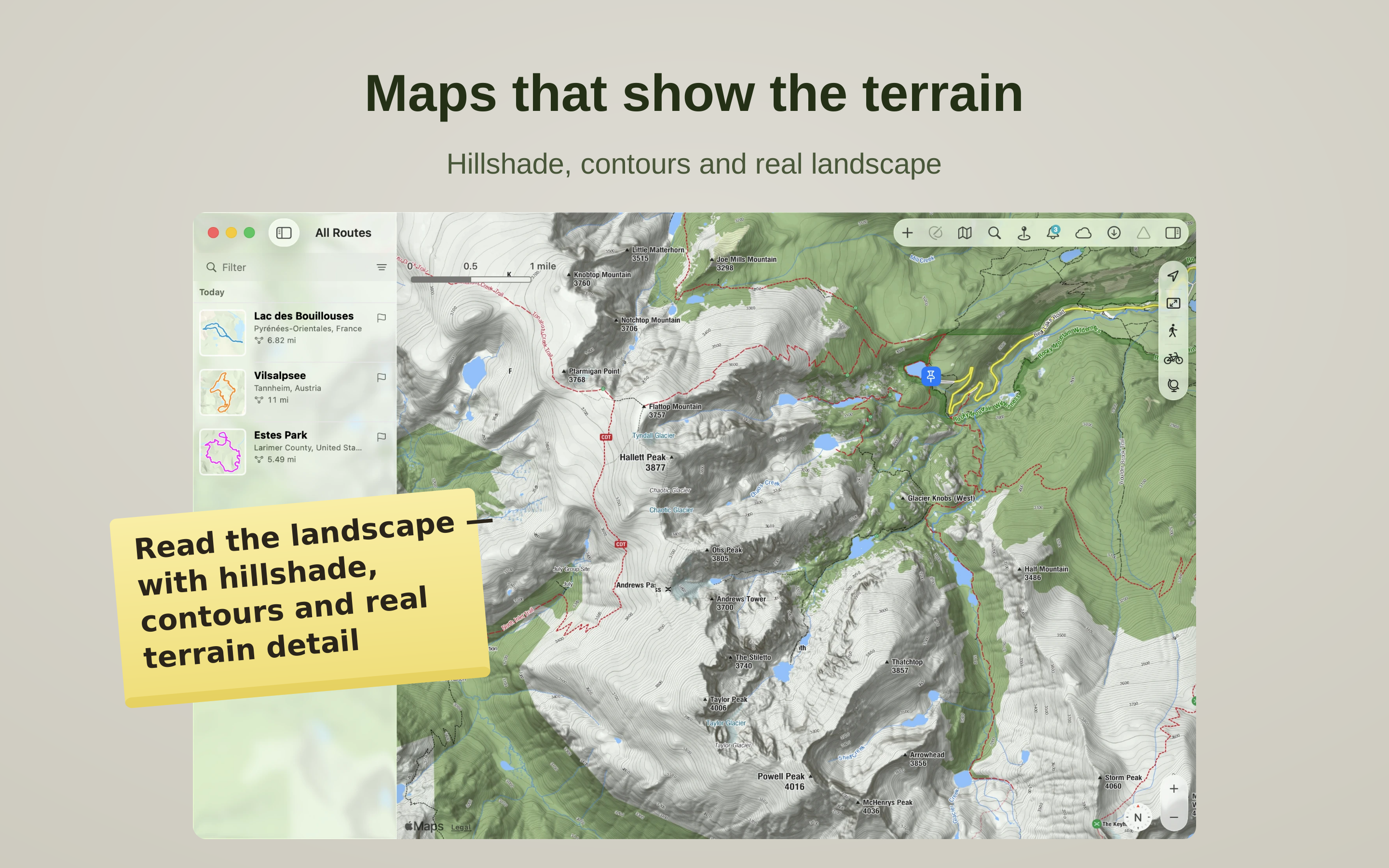
Maps that show the terrain

See the shape of the land, not just the lines on it. TrailRunner Mini draws topographic maps with hillshade and contour lines that bring out ridges, valleys and summits at a glance, and lets you switch between beautiful regional map styles. Read the terrain around your route and choose the paths that suit it.
Plan your perfect loop

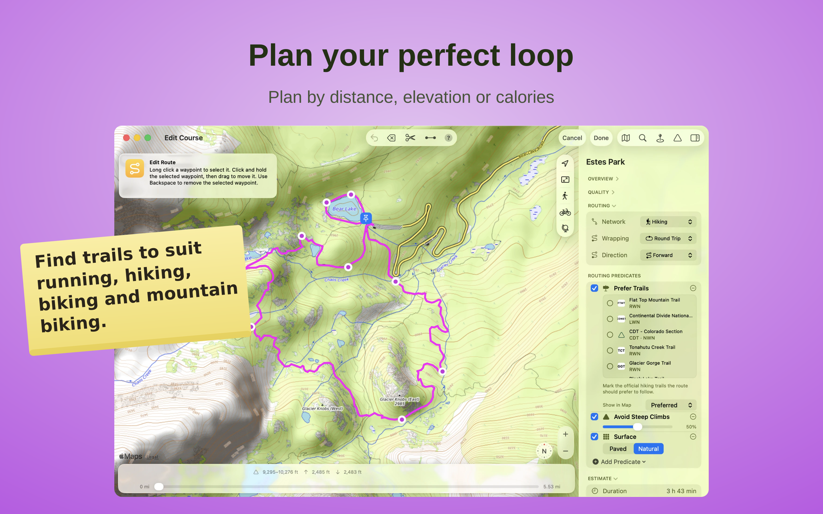
Plan your perfect loop

Build routes to your goals — distance, climb or calories — on ways suited to running, hiking, biking and mountain biking. Read the mountain before you go: see climbs, descents and the course of your route before you start, and enjoy the day knowing what lies ahead.

Your tour, on every device

Your tour, on every device

Import GPX, KML or Garmin TCX/FIT files and turn them into your own tour. Edit them, trim them or bring them back onto real trails without losing the original course. Your routes, collections and landmarks stay in sync across Mac, iPad and iPhone.

What people say

★★★★★Wandern
Super!!!
Sehr einfach können Fahrradtouren geplant werden und danach auf die SMART-Watch oder das Mobiltelefon geladen werden
Echt eine super Hilfe um selbst in unbekanntem Gebiet punktgenau navigieren zu können!
Sehr zu empfehlen.
PS: Kann auch für Wanderungen, Stadttouren, Skitouren, usw. verwendet werden.
— tschusi8032 · CH
★★★★★Wandern
Weiter so
Immer wieder schön seine Wanderungen hier am PC planen zu können.
— HB3XEI · CH
★★★★★Allgemein
Route für Veloreise planen
Top zum bedienen. Was mir noch fehlt sind Punkte um Notizen am ausgewählten Ort einzufügen. Gibt es dies schon? hab ich das noch nicht gefunden?
Wunderbare App! Danke
— Outdoor 2 go · CH
★★★★★Allgemein
Super App
Super, benutze den Trailrunner für meine Tourenplanung
— 2wheels4you · CH
★★★★★Laufen
Absolut zufrieden
Diese App nutze ich seit mehr als 2 Jahren mehrmals wöchentlich. Bin absolut zufrieden, weil meine Ansprüche als langjähriger Läufer voll erfüllt werden. Auch ist bei Problemen mit dieser App ein sehr guter Support (bernie der Entwickler) vorhanden, hier wird echt schnell und unkompliziert geholfen.
— MarcJaus · CH
★★★★★Wandern
Genial!
Die App wurde mir von einem Freund empfohlen, ich habe mir gleich zu Beginn die Lizenz gekauft. Die App ist super, ich benütze sie um Mountain-Bike und Wander-Touren zu planen und auf mein GPS-Gerät zu speichern. So sehe ich schon im Voraus, ob die Distanz und die Höhenmeter machbar sind. Die App ist einfach zu bedienen, alles wird erklärt und wenn man mal Probleme hat, kann man dem Ersteller der App schreiben und bekommt sehr schnell Hilfe. Ich kann die App wärmstens empfehlen.
— Ahorn74 · CH
★★★★★Laufen
Zum planen zu Hause sowie in der Ferne
Ich benutze die App jede Woche aufs neue. Ich planne unsere Rennradtouren (manchmal landen wir auf nicht asphaltierten Strassen, aber das hat mehr mit Cycle OpenStreetMap zu tun), MTB-Touren und Wanderungen. Sogar für Sea-Kajak Touren benutze ich es um die Tages-Etappen Weite zu plannen (dank der Off-Road Funktion). Ob man dann unterwegs die iPad Version oder den Racebunny (gesynct über iCould) braucht oder ein Garmin oder anderes GPS Gerät mittels Export/Import von GPX benutzt sei jedem selbt überlassen. Ich brauche die GPX Daten manchmal sogar um Runkeeper uptodate zu halten, sollte ich mal wegen mangles Akku eine Tour nicht getracked haben.

Für mich ist diese App unerlässlich und erleichtert die Wochenendplannung zu Hause sowie die Ferienplannung. Von vielen Wander und Bikeführer kann man die Touren per GPX runterladen. Diese in die App zu importieren ist kinderleicht. Mittels Racebunny und der Offline Pre-Loading Möglichkeit hat man dann alle Routen auch im Ausland zur Hand, ganz ohne Roaming.
— rockandmusic · CH
★★★★★Offline
Einfach genial!
Ausgangslage:
Ich war vor ca. 4 Jahren mit GPS-Geräten ausgerüstet und war auf der Suche nach einem Programm, das mir meine Expeditionen in verschiedenen Sportarten auf eine Karte bringt. Wenn möglich so, dass später mit sportlich schwächeren Personen anhand eines Höhenprofils und der Streckenlänge die Machbarkeit eingeschätzt werden kann und auch die Kräfte dementsprechend eingeteilt werden können.

Nutzung:
Zuerst war ich auf der App Trailrunner unterwegs, jetzt Trailrunner Mini aus dem App-Store.
Zu Beginn hatte ich Mühe, dass die vielen Import-Funktionen des Original Trailrunner für iPhone etc. nicht mehr zur Verfügung standen, doch korrekterweise muss ich zugestehen importiert es 4 GPS-Standarts, wobei ich GPX und KML regelmässig nutze und dies problemlos funktioniert - auch der Export. Somit wurde die Schnittstelle aus meiner Sicht korrekt erstellt: GPS-Uhren, Smartphones etc. produzieren Standart-GPS Daten, diese werden dann importiert.
Von Beginn her erfreute ich mich über die verschiedenen Basis-Karten. Meiner Meinung nach wäre eine Offline-Version auch anstrebbar, zumindest für freies Kartenmaterial, ist für mich jedoch nicht dringend nötig (Zukunftsmusik), deshalb kein Punkteabzug.
Eine Route kann auch erstellt und geplant werden, wobei hier zu erwähnen ist, dass der Editor sehr intuitiv ist. Punkte können dem Weg folgen, oder Offroad gehen, für die Erstellung kann hier viel Zeit eingespart werden. Wichtige Orte können markiert werden und als Basis für weitere Karten genutzt werden. Abgesehen von ein paar kleinen Unstabilitäten funktioniert das Top!
Die einzelnen Kartenausschnitte können gruppiert werden, zum Beispiel nach Regionen oder Ortschaften, damit man nicht an Kartenmaterial überhäuft wird.
Beim Laden eines Trails zeigt das Programm genau das an was man möchte: Karte und Höhenprofil, sowie eine Infobox über den STandort und die Leistung bei verschiedenen Aktivitäten! Das ist genau die Info die man braucht - nicht zuviel nicht zuwenig. Für genauere Analysen kann im Trail (Kartenausschnitt), sowie im Höhenprofil Teilstrecken oder Punkte verglichen werden. Je nachdem werden dafür wieder spezielle Angaben zu Höhe, Distanz und Zeit angegeben. Wirklich super! Klar muss man im Hinterkopf behalten, dass es sich insbesondere bei den Leistungen um Schätzungen handelt und die wahren Gegebenheiten (Schwierigkeitsgrade etc.) im Hinterkopf zu behalten sind.
Eine langsame Reaktion des Programmes konnte ich bisher nur im Zusammenhang mit dem Laden des Kartenmaterials (Internetverbindung) feststellen und läuft sonst sehr flüssig (-> hier wäre wohl eine Offline-Kartenversion vielleicht mal eine Zukunftsidee).

Fazit: Trailrunner ist der Missing-Link zwischen Geodaten (Google Maps, Google Earth) und den Trainingsanalysen aus den Fitnesscenter und eignet sich ideal für Menschen, welche sich gerne in der Natur bewegen und Touren planen wollen, sowie in Erinnerungen schwelgen möchten. Da das Programm alles bietet und kaum Unstabilitäten aufweist gebe ich diesem Programm aufgrund der intuitiven Bedienung 5 Punkte! Danke und weiter so!
— Maknu777 · CH
★★★★★General
The Best Route Planner
I use this program for a couple of years now. I'am still very happy with it. It's getting better al the time. Importing GPX files, or creating them. Its a peace of cake. Go on Even now in 2024.
This message is still valid in 2026.
— Bernardj23 · NL
★★★★★Hiking
The easiest way to create your own walks, hikes, city tours
I’ve been using this program for years now and it’s by far the best way to create all sorts of walks. I use it both for walks in a city, simply connecting the most important landmarks, museums and shops. But also in nature it’s perfect for planning my hikes or walks. I usually export the trail as kml and import it in MAPS.ME or I sync it with Racebunny, which is made by the same developer as Trailrunner mini.
— wimvdmeer · NL
★★★★☆General
Mooi pakket van snel reagerende ontwikkelaar!
Mooi pakket waarop je eenvoudig je routes kunt plotten door het ingeven van tussenstops. Op basis van kaarten wordt het ontbrekende stuk route dan automatisch ingevuld. Dit gaat in het algemeen snel. Zelf gebruik ik de functie voor het vastleggen van routes die ik met de auto heb gereden in het buitenland. In dat geval reageert het pakket soms iets langzamer, vermoedelijk omdat er meer keuze mogelijkheden zijn voor het invullen van de stukken tussen de stops.

Het pakket laat je gebruik maken van verschillende soorten kaarten. De ene kaart is mogelijk geschikter voor het vastleggen van wandelingen en fietstochten, terwijl de andere kaart geschikter is voor het vastleggen van autoritten. Allerlei zaken zoals duur van de tocht, afgelegde afstand, hoogteverschil en geschat calorieverbruik regelt het pakket automatisch.

Wel opvallend is dat, als een route 's winters dicht is, je dan ook geen route kunt plotten. Zomers lukt het dan wel weer. Hetzelfde ervaar ik overigens met Apple Maps, dus misschien dat het daarmee te maken heeft.

Je kan kiezen tussen licentie en abonnement. Mijn voorkeur heeft het eerste, maar ik snap dat een ontwikkelaar op zoek is naar een langdurige inkomstenstroom. Kijk naar Adobe of MS.
— RNKLN · NL
★★★★★General
Best trail generator I have found!
I use trailrunner on literally every active vacation. It finds all trails and even the smaller and overgrown ones. It is easy to use and easy to export!
— ZzbashVi · NL
★★★★★Cycling
Great for drawing bicycle routes
I use TrailRunner mini for drawing bicycle routes. Pretty fast and uncomplicated. For holidays abroad or a ride nearby. Quick export to GPX and import on my iPhone and I'm good to go.
You click on a map and TR mini 'connects the dots'. Most of the time using the best roads for cycling. If you want to change the route, you just move or delete the markers and TR mini connects them, using actual roads on the map.
— Arthur Visser · NL
★★★★★Cycling
Impressive app with very detailed cycle roads to drive
Comprehensive app for cyclists fans
— phili2beat · NL
★★★★☆Running
TrailRunner Mini + RaceBunny = a winning combo!
I use TrailRunner Mini for planning cycle trips in and around where I live. I can plot routes with surprising accuracy and colour code them for different trips; distances are shown automatically. Occasionally there are small glitches when the map doesn’t have quite enough information but these are negligible and easy to correct. The app is easy to use and the iCloud sync with the companion iOS RaceBunny app works a treat so I can take my routes with me when I’m out. The dev also responds very quickly and effectively in the event of any problems. Highly Recommended.

Update feb20: In my earlier review I was enthusiastic about TrailRunner Mini in combination with RaceBunny. However, since recent updates it no longer works for me under MacOS 10.13 High Sierra. It is now impossible to edit existing routes as pins simply disappear when I try to select them. I contacted the dev but he can only suggest that I upgrade to Mojave or Catalina. This is not an option for me as I have too many apps that won’t run under these newer systems.
So beware: whilst the info in the Mac App Store states that the minimum system requirement for TrailRunner Mini is MacOS 10.11, it may not function properly under anything less than 10.14/15. I paid for a lifetime license and am sad, and rather cross, that I can no longer use what was an otherwise very useful app.
— Kritikus Ster · NL
★★★★★General
Prima app
Jammer dat ze me voortdurend om een recensie blijven vragen...
— Hoofi · NL
★★★★★MTB
perfecte app
deze app is een must voor iedereen die een navigatie in bezit heeft maakt niet uit of je een garmin of bryton hebt of welk merk dan ook.
je kunt zelf routes maken of routes erin plakken en overschrijven.
tevens staan er bijna alle paadjes op .
ik gebruik hem zelf om te mountainbiken.
— a 73 · NL
★★★★☆Hiking
Best app to manage your GPS files so far
Pretty good app to build your own librairy of your gps files. Berbie used lots of the build in OSX features which makes the app feel really apple-a-like. I like the designated hiking trails feature to prepare MTB trips.

What I would like to see in the future:
- Edditing of logged gps files, clear them up and stuff like that.
- The userexperience could all be a bit smooter but think the maps are so big in file size it suffers a bit from that.
Enjoy the app!
— Michiel sexappeal · NL