maps
Background routes
2018-06-19 10:28 Stored in:Help
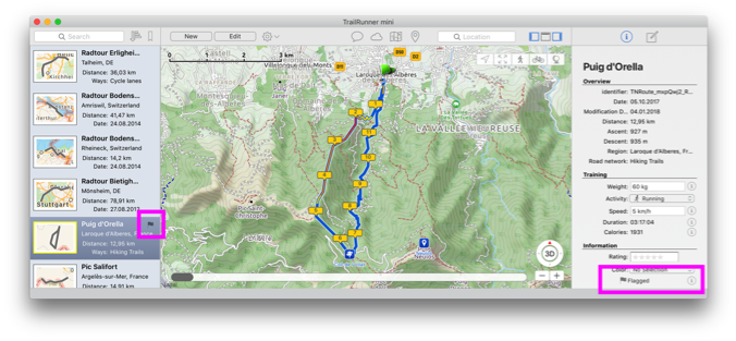
When you select a route in TrailRunner mini, the course is displayed in the map. But sometimes you may want to permanently display the route in the map, e.g. for planning alternatives or by making them visible as your path to follow when using RaceBunny while you are on your way biking or hiking.
You either flag a route by selecting the flag in the right information area or by selecting the flag in the left list of routes:
You either flag a route by selecting the flag in the right information area or by selecting the flag in the left list of routes:
How can I add a trail that is missing on the map
2019-09-18 16:48 Stored in:Support
Problem: TrailRunner mini uses the OpenStreetMap network create routes along the transit locations you set. But sometimes the OpenStreetMap data is not complete, misses a link between two paths or has wrong path attributes like planning along a seemingly public way though the way is private or blocked in reality. This may lead to strange routes being calculated by TrailRunner mini.
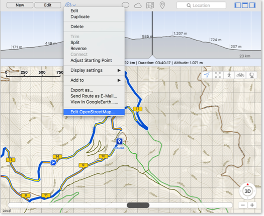
Contribute: OpenStreetMap is like wikipedia for maps. Everyone can contribute, extend and correct the maps. There is a very convenient editor existing you may use to edit the open openStreetMap maps.
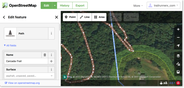
After making changes to OpenStreetMap, it takes a couple of hours until your changes have have made it into the routing engine of TrailRunner mini.
As TrailRunner mini may still have cached the old data, use TrailRunner mini > Clear Caches… to make sure the new data is downloaded and becomes visible in the map.
Alternatively you can build a local missing link by creating an off-road section within your planned route.
How can I reset the application cache
2015-12-09 15:45 Stored in:Support
TrailRunner mini heavily caches most downloaded data for a couple of days. Should you need immediate updates or in other cases where you have problems with the cached data, you may reset the maps cache using the following command.
- Quit TrailRunner mini
- Start Terminal.app
- paste this line followed by pressing the return key:
- Quit TrailRunner mini
- Start Terminal.app
- paste this line followed by pressing the return key:
rm -rf ~/Library/Containers/com.berbie.trailrunnermini/Data/Library/CachesCan you add more map sources?
2013-08-17 12:26 Stored in:Conceptual
Problem: The map data being displayed by TrailRunner mini misses some trails or streets. But these are visible in other sources like Google Maps. Can you add these maps to TrailRunner mini?
Explanation: TrailRunner mini is based on the OpenStreetMap project. When you create routes, TrailRunner mini follows a hidden network of trails and streets that is based on OpenStreetMap data. The same data is being used to render the visible map. Would I add different map sources like Google Maps, the trail or street may be visible to you but you still cannot use it within the routing editor. This would be very frustrating and therefore I will not add this feature to TrailRunner mini — just because the App is supposed to be a simple route planning tool and no professional mapping solution.
Hint: But what you can do is to contribute to the OpenStreetMap project and fix the problem at its root.
Update: In recent builds of TrailRunner mini and RaceBunny you can choose between different map Sources. But please understand that these still are based on the openStreetMap project data and therefore cover the same level of detail, though the design may differ.
Expert Hint: When you click on the map toolbar icon in TrailRunner mini, select the option to display more map sources. Then choose any of the available. But please understand that these may display different data than the routing editor can display. If that is the case you may use the off-road routing feature to follow these ways.
How can I move the aspect of the background map?
2011-05-09 13:37 Stored in:Help

Solution:
To move the aspect of the background map, click and hold until the hand cursor appears. Keep holding and move the mouse to change the aspect.
Tip:
To zoom into a location, double-click the location.
Use the key combinations ⌘+ and ⌘- to zoom in and out at the center of the background map.
On Multi-Touch capable input devices use the gestures to zoom and scroll in any direction.
Why do maps sometimes switch to satellite and roads?
2010-12-22 09:42 Stored in:Conceptual
Problem: When you zoom in or out the maps automatically switch to another theme or obviously the "wrong" map type is being displayed.
Background: Not all map sources are available at all resolutions and in all areas of the world. So if the resolutions range of geographical coverage for a map source is exceeded, TrailRunner will display the best logical match it can find. For high resolutions this is satellite and for low resolutions this is roads.
Background: Not all map sources are available at all resolutions and in all areas of the world. So if the resolutions range of geographical coverage for a map source is exceeded, TrailRunner will display the best logical match it can find. For high resolutions this is satellite and for low resolutions this is roads.