How does TrailRunner mini import and export the GPX file format
2019-03-24 19:38 Stored in:Conceptual
The GPX file format (https://en.wikipedia.org/wiki/GPS_Exchange_Format) is an open standard that describes geographic information.
Within that format there is a conceptual difference between three types of point information:
Whenever you export files from external sources and import them in TrailRunner mini, try to keep the data straight within the expectations of TrailRunner mini. Some applications may export tracks as a series of wpt-tags which leads to serious misunderstandings within TrailRunner mini.
There are some type conversion tools out there that may help. Like http://www.gpsbabel.org
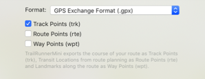
When you export routes in the GPX format to be displayed on other devices, the same applies. Some apps may not make a difference between track/route and way-points and may display all at the same time. To avoid this, you most likely want to export your route containing trackPoints only.
Read more:
• What are landmarks and waypoints?
Within that format there is a conceptual difference between three types of point information:
- Track-Points:
this is a raw recording representing a course. TrailRunner mini creates track-points as a result of a calculated route (the course you see on the map) - Route-Points:
: this represents a stop point on a route and is represented as a transit location (routing pin) in TrailRunner mini. Given two transit locations, TrailRunner mini calculates a track between these using the OpenStreetMap Network. - Way-Points:
this represents a landmark in TrailRunner mini.
Whenever you export files from external sources and import them in TrailRunner mini, try to keep the data straight within the expectations of TrailRunner mini. Some applications may export tracks as a series of wpt-tags which leads to serious misunderstandings within TrailRunner mini.
There are some type conversion tools out there that may help. Like http://www.gpsbabel.org
When you export routes in the GPX format to be displayed on other devices, the same applies. Some apps may not make a difference between track/route and way-points and may display all at the same time. To avoid this, you most likely want to export your route containing trackPoints only.
Read more:
• What are landmarks and waypoints?