TrailRunner 1.6 - Export and Retrace
09.01.08 01:17 Filed in: Features
The next major release step will bring a highly requested and an intuitive new feature.
 The former is a new route export pane. It will appear on Send To GPS and Save as GPX, will let you select more than one route to be exported and has the following options:
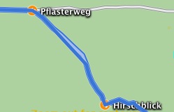
Boundary route: The idea behind this is to get all crossings exported without exporting the whole track network. As a track network is not part of the conceptual background in GPX files, this "pseudo" route will act as a hull around the selected route. Unfortunately my Garmin ForeRunner is not able to display more than one course at a time but it might be useful in other cases.
Compression: If you export more than one route into a GPX file the amount of data might overrun your devices memory limits. Compression might help to reduce the amount. A visual preview of the selected track depicts what the compressed track looks like.
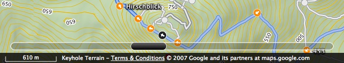
The latter new feature are track animations and a route slider. If you previously selected a checkpoint in the left hand table and used the arrow-down key to browse through the course of your route (what I do to memorize the course before I go out, even though you have electronical cheat sheets like NanoMaps and Send To GPS) TrailRunner will now retrace the course of the track segment up to the next checkpoint. Additionally, the new route slider at the bottom of the map lets you browse through the course of the route much the same way as coverflow in Leopard does with files.
If you are a thrill seeker or would like to be a cheer leader, download a nightly build here:
> Download
Enjoy!
At this point I'd like to thank everybody who gave me feedback and motivation for the TrailRunner project in the past year. The project still satisfies me very much and we'll see many more updates in the future. All the best to everybody for 2008…
Boundary route: The idea behind this is to get all crossings exported without exporting the whole track network. As a track network is not part of the conceptual background in GPX files, this "pseudo" route will act as a hull around the selected route. Unfortunately my Garmin ForeRunner is not able to display more than one course at a time but it might be useful in other cases.
Compression: If you export more than one route into a GPX file the amount of data might overrun your devices memory limits. Compression might help to reduce the amount. A visual preview of the selected track depicts what the compressed track looks like.
The latter new feature are track animations and a route slider. If you previously selected a checkpoint in the left hand table and used the arrow-down key to browse through the course of your route (what I do to memorize the course before I go out, even though you have electronical cheat sheets like NanoMaps and Send To GPS) TrailRunner will now retrace the course of the track segment up to the next checkpoint. Additionally, the new route slider at the bottom of the map lets you browse through the course of the route much the same way as coverflow in Leopard does with files.
If you are a thrill seeker or would like to be a cheer leader, download a nightly build here:
> Download
Enjoy!
At this point I'd like to thank everybody who gave me feedback and motivation for the TrailRunner project in the past year. The project still satisfies me very much and we'll see many more updates in the future. All the best to everybody for 2008…