TrailRunner SneakPeek — Contour Overlay and Terrain Map Source
02.12.07 13:37 Filed in: Maps
Today I added a contour layer to background maps. The contour data comes from the same USGS data source as the already known elevation download. But the transparent overlay is something being calculated and provided by Jonathan Stott from www.earthtools.org.
Earthtools is a cool service anyway. Hopefully it will stay free for a long time. As long as it is, enjoy the contours.
The display settings you'll find under Document Settings > Additional Settings > Contour : Show/Hide
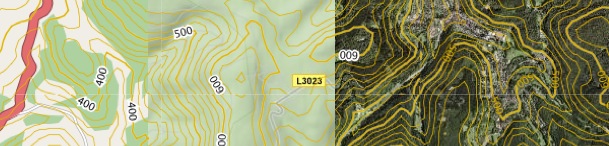
The examples above show a region with the contour overlay applied to three background map sources. On the right with satellite imagery and left with openstreetmap.org. As a sidenote I realized that openstreetmap really gets a momentum. I am very pleased for the quality and detail the service now offers. As maps at openstreetmap.org change often, please regularly empty your map cache.
File > Consolidate > Empty Caches
The other news are terrain maps from Google. As you can see in the middle image, also with overlay contours applied.
> www.earthtools.org
> www.openstreetmap.org
> maps.google.com