DTK Maps - Cutting Edge
03.02.09 08:49 Filed in:
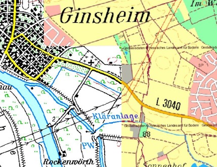
TechnologyI worked on the optimization for map borders. The problem in prior versions of TrailRunner was that when one map provider had no more maps for a region I should automatically switch to the new map provider. What I now do is that I check for each tile being loaded from what WMS server I should get it from. The screenshot shows a cut between the two Maps sources
Rheinland-Pfalz TK25, copyright Landesamt für Vermessung und Geobasisinformation Rheinland-Pfalz (LVermGeo) and
Hessen ATKIS 50, copyright Hessisches Landesamt fuer Bodenmanagement und Geoinformation.
The funny thing in this picture is that I thought the left map was originally a scanned paper map and the right map was a digital vector map. That could still be true but as you can see with the word "Kläranlage" in the middle of the maps, the word is perfectly aligned on both sources.
Looks like god even planned the locations for
clarification plants when he created the world.
Tags: Maps